Your gateway to a wide range of natural resources information and associated maps

Victorian Resources Online

Sites of Geological and Geomorphological Significance - Foster

Back to: West Gippsland Sites of Geological and Geomorphological Significance Map

This is a clickable map. Click on site in Legend for detailed information.
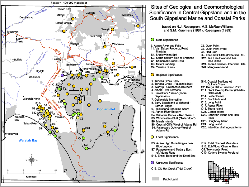
Sites of Geological and Geomorphological Significance - Foster

Sites of Geological and Geomorphological Significance - Foster
State Significance
6 Agnes River and Falls11 Van Dykes Property, Point FranklinS1 Shallow Inlet SpitS2 South-eastern side of Entrance
C1 Chinaman Creek DeltaC3 Millers LandingC4 Yankie DunesC6 Duck Point
C7 Duck Point WestC8 Red BluffC9 The Chalk Cliffs (Patterson Road)C12 Tea Tree Point and Tea Tree Island
C19 Toora Channel - Intertidal FlatsC20 Mangrove Island
Regional Significance
1 Turtons Creek Falls2 Turtons Creek - Palaeozoic Inlet3 Wonyip - Cretaceous Boulders4 Albert River Terraces
5 Hazel Park "Basin" (Toora Depression)7 Gelliondale Monocline8 Barry Beach and Welshpool - Barrier Ridges9 Pleistocene Shoreline Scarp
10 Agnes River EstuaryS4 Siliceous Dunes - Red SwampS5 Winchesters Bluff ("Tallanandbar")S6 Marsh Islands
S8 Coastal Cliffs West of Adams RoadS9 Palaeozoic Outcrop West of Adams RoadS10 Coastal Sections at Quine's CreekC2 Barry's Hill to Bennison Point
C11 Black Swamp Barrier (Charles Hall Road)C14 Foster BeachC15 Franklin IslandC16 Long Point
C17 Agnes RiverC18 Toora IslandC21 Corner IslandC22 Bennison Island and Tidal Flats
C23 Doughboy IslandC24 Long IslandC26 Inter-tidal drainage patterns
Local Significance
S3 Active High Dune Ridges near Blue LagoonS7 Palaeozoic and Tertiary East of Adams RoadS11 Ennis' Bend and the Dead EndS12 Tidal Channel Meanders
S13 Ebb/Flood Channel BarsC5 Townsends PointC10 Cotters Swamp Foreland
Unknown Significance
C13 Old Hat Creek (Tidal Creek)
Page top