
20. Mangrove Island
This information has been developed from the publication:
|
| Location | 415153. Two km south of Toora Beach. |
Access: | Boat access only at high tide from Lawsons Gutter off Toora Channel. |
Significant Features: | The site encloses Mangrove Island and an areas of the surrounding inter-tidal flat. The island is surrounded by and almost covered with dense, apparently even-aged strands of mangrove most only 1 m high forming a continuous low level canopy. There is a small area of slat marsh and a large number of open ponds surrounded by mangrove. A pool-and-channel tidal drainage pattern has developed around the island below mid-tide level. Several large shell banks have stranded on the tidal flats south of Mangrove Island. |
Significance Level: | State. Teh island is an example of the early stages of marsh island formation. Unlike other marsh islands in Corner Inlet, the mangrove fringe is intact although some recession of mangrove edges is beginning. |
Management Issues: | Considerable damage to the mangroves is caused by walking across the island. Landing and traversing should be excluded and the island placed in a special management zones. |
Research & Monitoring Requirements: | Base line transects should be established to monitor change in the island configuration. Aerial photography can be used to determine the development of the tidal drainage pattern. |
Public Interpretation Possibilities: | No applicable. The island is too sensitive to use as a public site. |
Main References: | Vertical aerial photographs. |
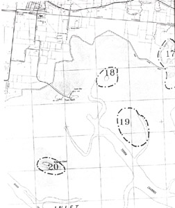 Sites 17 (Agnes River), 18 (Toora Island), 19 (Inter-tidal flats) and 20 (Mangrove Island) | 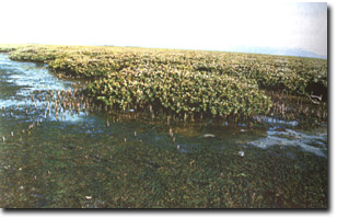 Dense, even-height stand of mangroves, Mangrove Island |
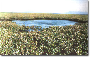 Pond in mangroves, Mangrove Island |
© State of Victoria (Agriculture Victoria) 1996 - 2025.

This work, Victorian Resources Online, is licensed under a Creative Commons Attribution 4.0 licence. You are free to re-use the work under that licence, on the condition that you credit the State of Victoria (Agriculture Victoria) as author, indicate if changes were made and comply with the other licence terms.
The licence does not apply to ‘branding’ or some ‘images or photographs’ that may be owned by third parties. We ask you to seek prior approval to use images using the VRO feedback form. Access to higher quality images can also be provided on request.
This page was last updated on 25/01/2019.