
8. Coastal Cliffs West of Adams Road
This information has been developed from the publication:
|
| Location | 255057. Three hundred metres north-west of Adams Road. The cliffed section extends for about 200 metres. | 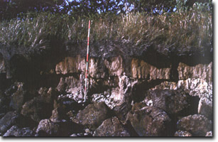 Pleistocene lagoonal sediments resting on Pliocene clay beds, (near Adams Road) |
Access: | Walk from south end of Adams Road. | |
Significant Features: | Cliffs eroded along the northern shore of Shallow Inlet west of Adams Road expose Pliocene and Pleistocene sediments. The Pleistocene sediments are leached fine sands (lagoonal sediments) overlying coffee-rock which rests unconformably on Pliocene clays. The site is of interest both for exposures of sediments and because a Juncus marsh is spreading in front of this formerly active cliffed sector. The marsh is advancing across firm sandy tidal flats derived from former episodes of cliff erosion. As the marsh is widening, the rate of cliff erosion reduces due to protection from wave action. | |
Significance Level: | Regional. The site is an example of ecological change (marsh growth) leading to a change (reduction) in shoreline stability. It is also significant for sections of Pleistocene lagoon deposits exposed in cliffs. | |
Management Issues: | This sector of coast should be excluded from erosion protection schemes. The impact of the erosion needs to be evaluated as to purpose and effectiveness. The viability of using vegetation as a protective measure need evaluating. | |
Research & Monitoring Requirements: | Establish detailed mapping project to monitor rates of cliff erosion and development of marsh. | |
Public Interpretation Possibilities: | Not applicable. | |
Main Reference: | Smith, A. S. (1969). 'The geomorphology of Shallow Inlet, Victoria.' B.Sc. (Hons) Thesis. Dept. of Geography. Univ. of Melb. | |
 Shallow Inlet (south and north) | 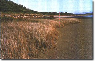 Juncus marsh advancing in front of eroded cliffs west of Adams Road |
© State of Victoria (Agriculture Victoria) 1996 - 2025.

This work, Victorian Resources Online, is licensed under a Creative Commons Attribution 4.0 licence. You are free to re-use the work under that licence, on the condition that you credit the State of Victoria (Agriculture Victoria) as author, indicate if changes were made and comply with the other licence terms.
The licence does not apply to ‘branding’ or some ‘images or photographs’ that may be owned by third parties. We ask you to seek prior approval to use images using the VRO feedback form. Access to higher quality images can also be provided on request.
This page was last updated on 25/01/2019.