
14. Foster Beach
This information has been developed from the publication:
|
| Location | 345165. Coast extending 1 km east from Foster Beach. |
Access: | Foster Beach Road. |
Significant Features: | The site presents a contrast in coastal processes in a traverse beginning at Foster Beach and extending east for 1 kilometre. At Foster Beach the coast is eroding - in places very rapidly - and stages in the erosion process are indicated by remnants of sea walls and groynes. A derelict timber wall is now 20 to 40 m seaward of high water mark and there present coast is an eroding Melaleuca terrace with many undercut and fallen trees littering the shoreline. A more recent wall of cemented stone blocks extends for 150 m at the end of Foster Beach Road. This new wall in places is undercut and breaking up at the eastern end and the coast behind this is being extensively cut back by erosion. |
Seven hundred metres east of Foster Beach is a spreading stand of Spartina over 150 m wide. The grass is extending across a firm sandy flat only sparsely occupied by mangroves. It has crossed the tidal channel separating Franklin Island is invading the tidal flat on the west of that island. | |
Significance Level: | Regional. The site illustrates rapid and sustained erosion of an exposed coast. A broad zone of mangrove and salt marsh has been eroded to expose a Melaleuca zone in which erosion is accelerated as trees fall and drag out large blocks of peaty soil. The site shows the limited success achieved by partial sea wall construction. By way of contrast, the eastern part of the site shows the change in coastal stability and sedimentation as a result of Spartina invasion. |
Management Issues: | The effectiveness of sea wall emplacement at Foster Beach needs to be evaluated. If coastal engineering works are deemed necessary, a better design than the present decaying structure is urgently required. |
Research & Monitoring Requirements: | The rate of coastal retreat needs to be determined based on historical data and aerial photograph interpretation. A similar study is required for the Spartina site. Permanent transects are needed at several parts of the site to evaluate current rates of changes and in particular to monitor the rate of Spartina spread. Advice from ecologists on management of the grass is required. |
Public Interpretation Possibilities: | The site is of interest to students of coastal engineering and coastal change and is an accessible site to display Spartina growth. Sequential photographs and maps of coastal change could be shown at a visitor centre. |
Main References: | Vertical aerial photographs. |
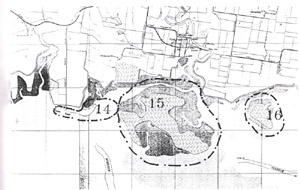 Sites 14 (Foster Beach), 15 (Franklin Island) and 16 (Long Point) | 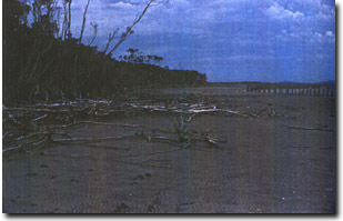 Erosion of Melaleuca terrace at Foster Beach |
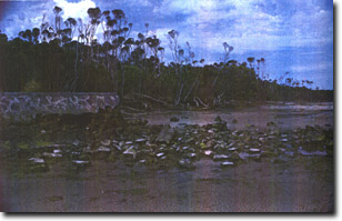 Destruction of seawall at Foster Beach | 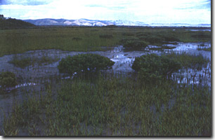 Spartina spreading across mangrove flat east of Foster Beach |
© State of Victoria (Agriculture Victoria) 1996 - 2025.

This work, Victorian Resources Online, is licensed under a Creative Commons Attribution 4.0 licence. You are free to re-use the work under that licence, on the condition that you credit the State of Victoria (Agriculture Victoria) as author, indicate if changes were made and comply with the other licence terms.
The licence does not apply to ‘branding’ or some ‘images or photographs’ that may be owned by third parties. We ask you to seek prior approval to use images using the VRO feedback form. Access to higher quality images can also be provided on request.
This page was last updated on 25/01/2019.