
12. Tidal Channel Meanders
This information has been developed from the publication:
|
| Location | 249048 Western side of Shallow Inlet opposite Adams Road. |
Access: | Boat access only. |
Significant Features: | Sinuous tidal channels lie on either side of a narrow salt marsh peninsula. The channels drain the northern and western arms of Shallow Inlet and have symmetrical meander loops that are eroding towards each other and may eventually breach the narrow salt marsh divide between them. |
Significance Level: | Local. |
Management Issues: | No dredging, draining or spoil dumping to be permitted. |
Research & Monitoring Requirements: | Mapping from aerial photographs. |
Public Interpretation Possibilities: | Aerial photo displays in visitor centre. |
Main Reference: | Vertical aerial photographs. |
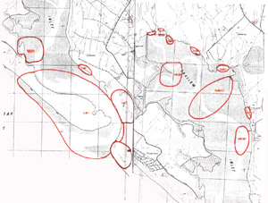
Shallow Inlet (south and north)
© State of Victoria (Agriculture Victoria) 1996 - .

This work, Victorian Resources Online, is licensed under a Creative Commons Attribution 4.0 licence. You are free to re-use the work under that licence, on the condition that you credit the State of Victoria (Agriculture Victoria) as author, indicate if changes were made and comply with the other licence terms.
The licence does not apply to ‘branding’ or some ‘images or photographs’ that may be owned by third parties. We ask you to seek prior approval to use images using the VRO feedback form. Access to higher quality images can also be provided on request.
This page was last updated on .