
1. Shallow Inlet Spit
This information has been developed from the publication:
|
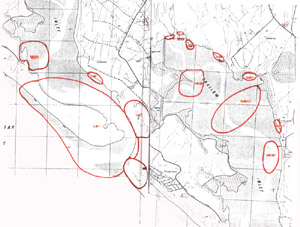
| Location | 262997 to 295967. The main body of Shallow Inlet spit and entrance extending from the western end of the spit to the eastern side of the entrance. The site includes spits and shoals on both sides of the entrance channel. | 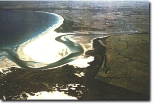 Shallow Inlet spit - aerial oblique photograph 1987 |
Access: | Walk from car parks at end of Sandy Point road. Boat landings are possible along the northern shore of the spit. | |
Significant Features: | East of Sandy Point township, the Waratah Bay barrier projects as a spit across the entrance to Shallow Inlet. The proximal end is narrow and the spit termines with a bulbous distal recurve. The morphology and dynamics of this spit can be traced by reference to a series of maps, descriptions and photographs dating back to 1841 and is an area of great geomorphological interest. | |
The western (proximal) end of the spit has a distinct "neck" caused by current and wave erosion on the outside of a meander bend in the main tidal channel in Shallow Inlet. Smith (1969) proposed that this neck would continue to narrow until breaching took place thus truncating the barrier. Such an event was observed by a resident of Sandy Point in August 1901 (F. W. Pilkington cited by Smith 1969). Following the breaching the truncated spit has gradually lengthened being nourished by a predominant easterly longshore drift. The tidal channel in the inlet has been deflected to the east and become more sinuous developing a new neck at the proximal end of the spit. Smith (1969) suggested that a further episode of beaching would take place after approximately 120 years. "Because of the number of variables....... involved....... the pattern of evolution is not a truce cycle in the sense of having a regular period, but it approximate a cycle with the repeated occurrence of the same events."” | ||
Cecil (1983) supported Smith’s analysis of spit growth and breaching concluding that… ".....the entrance to Shallow Inlet is a dynamic system with a repeated phase but no set periodicity."” | ||
The neck of the spit is now about 420 metres wide from high water mark Waratah Bay shore to high water mark Shallow Inlet (estimated from vertical aerial photograph taken 7.2.1987). The spit is higher on the Waratah Bay shore than inside Shallow Inlet (S. Cummins pers. comm.) suggesting that breaching is more likely to occur by ocean wave overwash rather than by flooding in Shallow Inlet. | ||
The bulk of the present spit is unvegetated but there is considerable variation in the form of sand accumulation both on the small vegetated area and the large area of mobile beach and dune sand. The expanse of sand (over 3.5 km long and up to 1 km broad), the degree of exposure and the temporal understanding of the spit formation combine to make this an important site for the study of various forms of dune accumulation. The spit is exposed to strong wave action from the south-west, the result of regular south-westerly to westerly ocean swell passing across Bass Strait and refracted around Cape Liptrap into Waratah Bay (Tuddenham 1970). This provides a steady alongshore and onshore flow of sand which is supplemented by a strong onshore wind resultant oriented almost due westerly. The dominant unvegetated dune form is fields of low sand ripples that resemble short, sinuous transverse ridges of barchanoid form. Near the proximal (western end) of the spit, the ridge axis of this is shore-parallel, but towards the distal end they become more shore-oblique. | ||
An increasing area of the Shallow Inlet sandspit has become vegetated since the early 1960s (Heyligers 1985). The dominant vegetated dune form is a hummock or hillock rising in excess of 5 metres, often with a lee or shadow dune of variable length. The biggest hummocks (highest and broadest) form around clumps of Ammophila arenaria with lower mounts centring on Festuca littoralis and Elymus farctus. There is relatively little Spinifex hirsutus and Cakile maritima on the exposed areas of the sandspit. The vegetated dune hummocks are concentrated along an 800 metre section of the spit and are considered to be well established and extending (Heyligers 1985). They are stabilising the spit, gradually coalescing into liner dunes and anchoring a greater volume of sand on the spit than would otherwise occur. The most widespread and vigorous plants are exotic species (Ammophila and Elymus). As Rosengren (1981) noted on the coast of East Gippsland, the arrival of exotic and vigorous sand-binding species on a shore with abundant aeolian and wave-borne sand is introducing a fundamental change in the rates and process of foredune accumulation that has wider physiographic implications. Heyligers (1985) also noted the increase in vegetation on coastal spits, remarking that at Sandy Point, there is ….. ".....no evidence that there was vegetation on the previous spits. In view of the large amount sand present accumulating on the spit, it is quite likely that when the next breakthrough occurs at the neck, the spit will not be totally destroyed..... as..... on previous occasions, but that the dune area will remain as an island." | ||
Significance Level: | State. The site is well documented and an outstanding example of barrier spit dynamics. It is a site of on-going research and an excellent and accessible locality to observe processes of aeolian, beach sand spit sedimentation. The significant features are: the dynamics and evolution of coastal dunes, hummocky dunes, linear dunes, barchanoid transverse dunes and the interaction of dunes and vegetation. The cyclic nature of spit growth, the evolution and dynamics of spits and entrance bars and shoals. The hydrology of the entrance channels and the changing pattern of ebb and flood channels is of particular interest in this regard. | |
Management Issues: | Vehicles to be kept off the spit area. The spit and entrance is a dynamic entity and substantial short and long term changes can be expected. Such changes should be allowed to continue and develop. Dredging and artificial re-alignment of the channel would detract from the significance of the entrance dynamics. Given the rate of channel and spit migration recorded over the past 10 years, it is possible that the spit may undergo a new breach in the next 10 years. | |
Research & Monitoring Requirements: | Permanent transects to be established to monitor dune/vegetation dynamics. Detailed vegetation mapping to determine distribution of exotic sand binding species. Annual aerial photographic and ground survey to monitor entrance dynamics and migration. | |
Public Interpretation Possibilities: | There are excellent display possibilities using sequential maps and aerial photographs to show entrance dynamics. Recognition of the role of sand binding plant species followed by field identification of dune morphology of vegetated and unvegetated dunes. | |
Main References: | Smith, A. S. (1969). 'The geomorphology of Shallow Inlet, Victoria.' B.Sc. (Hons) Thesis. Dept. of Geography. Univ. of Melb. Cecil, M. K. (1983). 'The evolution of the entrance to Shallow Inlet.' Geol. Surv. Vict. Unpub. Rept. 1983/71. Heyligers, P. C. (1985). 'The impact of introduced plants on foredune formation in south-eastern Australia.' Proc. Ecol. Soc. Aust. 14, 23-41. | |
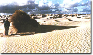 Ammophila hummocks, Shallow Inlet spit | 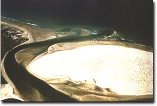 Distal end of Shallow Inlet spit, 1987 |
© State of Victoria (Agriculture Victoria) 1996 - .

This work, Victorian Resources Online, is licensed under a Creative Commons Attribution 4.0 licence. You are free to re-use the work under that licence, on the condition that you credit the State of Victoria (Agriculture Victoria) as author, indicate if changes were made and comply with the other licence terms.
The licence does not apply to ‘branding’ or some ‘images or photographs’ that may be owned by third parties. We ask you to seek prior approval to use images using the VRO feedback form. Access to higher quality images can also be provided on request.
This page was last updated on .