
19. Toora Channel - Intertidal Flats
This information has been developed from the publication:
|
| Location | 440160. Between Toora Channel and Jimmys Rivers (Tidal Channel) 2 km south-east of Toora Beach. |
Access: | Boat access from Toora Beach. The features are exposed at low tide. |
Significant Features: | The sandy intertidal area has a tidal drainage system of small circular and elongated depressions linked by shallow channels combining to form a dense network of varied pattern. The patterns range from extremely complex and occasionally chaotic systems of "intertidal" drainage to others where the ponds and channels form a regular rectangular or trellised drainage pattern leading into a main network channel. The ponds average 10 to 15 m diameter with the largest seldom over 20 m. The edges are well defined and often have a small scarp up to 30 cm high. The ponds seem to develop on the higher parts of those flats that have fine sandy substrates, with sparse Zostera cover. The ponds and channels are generally bare of seagrass. On more muddy tidal flats north of the Jimmys River tidal channel near the mouth of Agnes River, a fine parallel drainage pattern has developed, possibly from the amalgamation of an original pond and channel system. |
Significance Level: | State. This is a clear example of a common drainage pattern in Corner Inlet. The origins of the pools and the factors controlling the pattern have not been described in detail. There has been very little research on sedimentation and inter-tidal drainage in bays and inlets on the Victorian coast. |
Management Issues: | Dredging of channels and dumping of dredge spoil would obscure the pattern and interrupt the development of the drainage system. No engineering works should therefore be permitted across this area. |
Research & Monitoring Requirements: | The origin and dynamics of the system awaits explanation. A programme of mapping and sediment sampling would be the first element of such a research pattern. |
Public Interpretation Possibilities: | There is probably little public appeal at the site and the limited time available at low tide makes visitor access difficult. |
Main References: | Vertical photographs (Run 8 Frame 152). |
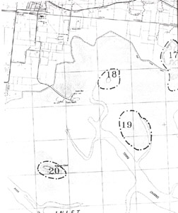 Sites 17 (Agnes River), 18 (Toora Island), 19 (Inter-tidal flats) and 20 (Mangrove Island) | 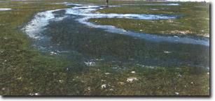 Shallow ebb-tide channel linking ponds on tidal flat south of Toora Island |
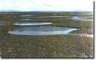 Circular ponds with incised margins on tidal flat south of Toora Island |
© State of Victoria (Agriculture Victoria) 1996 - 2025.

This work, Victorian Resources Online, is licensed under a Creative Commons Attribution 4.0 licence. You are free to re-use the work under that licence, on the condition that you credit the State of Victoria (Agriculture Victoria) as author, indicate if changes were made and comply with the other licence terms.
The licence does not apply to ‘branding’ or some ‘images or photographs’ that may be owned by third parties. We ask you to seek prior approval to use images using the VRO feedback form. Access to higher quality images can also be provided on request.
This page was last updated on 25/01/2019.