
11. Black Swamp Barrier (Charles Hall Road Site)
This information has been developed from the publication:
|
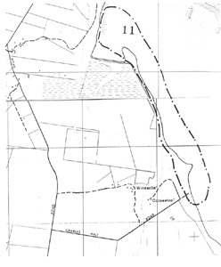
| Location | 302100. Extending north from Charles Hall Road to the embankment across Golden Creek. |
Access: | Charles Hall Road. |
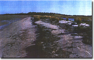
Significant Features: | The site extends from the eastern end of Charles Hall Road to the spit at the mouth of Golden Creek. It is an eroded coast that has been greatly modified by construction of embankment and drains the hinterland. The site is the outer edge of a drained tidal embayment and estuary of Golden Creek and is a remnant of a more extensive wetland and sand barrier. The present coast has 5 main elements: 1) a shore platform of cemented but rotted and weathered Haunted Hills Formation gravels and coarse sand; 2) a narrow moving barrier ridge or chenier of coarse sand; 3) a low eroding salt marsh terrace (partly covered by the barrier ridge with peat outcropping at the seaward edge; 4) a recurving spit (Golden Creek spit) built of parallel sand ridges; 5) a mangrove and salt marsh north of Golden Creek which is included for comparison with the coast to the south of the creek. |
The shore platform is not a primary abrasion feature but is a surface exposed due to erosion of overlying salt marsh. The apparent cuspate foreland just north of Charles Hall Road is really a chenier ridge beach plastered on an eroding salt marsh. Mangrove stumps seaward of the beach mark the position of the outer edge of the marsh and it is likely that mangroves once fringed the coast north to Golden Creek. Black Swamp is a drained mangrove and salt marsh swamp and the remnant pattern of tidal creeks across this indicate that the swamp was only partly impounded by a barrier formation. The swamp probably extended seaward behind a broad mangrove fringe, the extent of this now shown by the exposed "platform" surface. The barrier/chenier ridge and beach and the Golden Creek spit are therefore recent features post-dating the drainage and enclosure of Black Swamp. | |
Significance Level: | Regional. The site is one of substantial recent change. It illustrates a change in the style of coastal sedimentation (mangrove and salt marsh to sand chenier) and erosion of a former swamp coast. These may be closely related to drainage and enclosure of Black Swamp. |
Management Issues: | No drainage or removal of sand, gravel or rock materials should take place. Vehicles should not be permitted to drive along the beach. |
Research & Monitoring Requirements: | The explanation of coastal change given is tentative. More detailed work is required to verify the nature of recent changes. |
Public Interpretation Possibilities: | The site could be used to show the substantial and rapid changes that may occur on a mangrove, salt marsh coast. |
Main References: | Ferguson, W. H. & Kenny, J. P. L. (1927). Yanakie, Waratah North, Toora, Wonga Wonga North geological mapsheets 40 chains to one inch, Geol. Surv. Vict. |
 Site 11 | 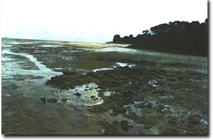 Eroding sand barrier and wide platform north of Charles Hall Road |
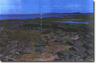 Rotted Haunted Hill Formation gravels on shore platform at Charles Hall Road | 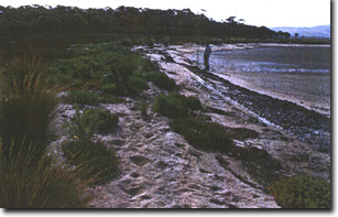 Eroding salt marsh peat and sand chenier (giving appearance of cuspate foreland) north of Charles Hall Road |
 Edge of eroding peat terrace and sand chenier near mouth of Golden Creek |
© State of Victoria (Agriculture Victoria) 1996 - 2025.

This work, Victorian Resources Online, is licensed under a Creative Commons Attribution 4.0 licence. You are free to re-use the work under that licence, on the condition that you credit the State of Victoria (Agriculture Victoria) as author, indicate if changes were made and comply with the other licence terms.
The licence does not apply to ‘branding’ or some ‘images or photographs’ that may be owned by third parties. We ask you to seek prior approval to use images using the VRO feedback form. Access to higher quality images can also be provided on request.
This page was last updated on 25/01/2019.