
10. Cotters Swamp Foreland
This information has been developed from the publication:
|
| Location | 320082. Fifteen hundred metres south east of Charles Hall Road, Yanakie. |
Access: | Charles Hall Road or Patterson Road. |
Significant Features: | The site is a remnant of a former swamp and tidal inlet which was part of the (now drained) Cotters Swamp to the north. An eroding Melaleuca peat terrace rests on rotted, iron-stained Haunted Hills Formation gravels which underlie the former swamp. The swamp was enclosed by broad sand ridges, remnants of which occur on cleared land immediately behind the coastal scrub. Westerly moving sand lobes are currently extending in front of the eroding terrace. |
Significance Level: | Local. The site is an example of several of the processes that shape this western shore of Corner Inlet and illustrates substantial recent change. |
Management Issues: | Cleared land extends almost to the coast. The boundary of Crown Land and private land needs to be verified. |
Research & Monitoring Requirements: | If the Crown Land strip here is as narrow as the cleared land suggests, rates of erosion and accretion should be evaluated by annual survey. |
Public Interpretation Possibilities: | Not applicable. |
Main References: | Ferguson, W. H. & Kenny, J. P. L. (1927). Yanakie, Waratah North, Toora, Wonga Wonga North geological mapsheets 40 chains to one inch, Geol. Surv. Vict. |
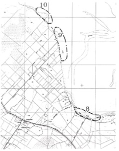 Sites 8, 9, 10 | 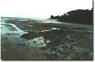 Eroding terrace and sandy foreland south of Cotters Swamp |
© State of Victoria (Agriculture Victoria) 1996 - .

This work, Victorian Resources Online, is licensed under a Creative Commons Attribution 4.0 licence. You are free to re-use the work under that licence, on the condition that you credit the State of Victoria (Agriculture Victoria) as author, indicate if changes were made and comply with the other licence terms.
The licence does not apply to ‘branding’ or some ‘images or photographs’ that may be owned by third parties. We ask you to seek prior approval to use images using the VRO feedback form. Access to higher quality images can also be provided on request.
This page was last updated on .