
4. Siliceous Dunes - Red Swamp
This information has been developed from the publication:
|
| Location | 285997 Eastern side of Shallow Inlet 1 km west of Warren Land and 500 metres south-east of Fisherman’s Creek. | 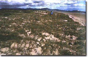 Leached siliceous dune, eastern shore of Shallow Inlet |
Access: | Boat access at high tide. Walk along inlet shore from camping reserve. | |
Significant Features: | The eroded channel edge exposes a cross section of siliceous dunes overlaid by calcareous sand. The base of the dunes rests on Tertiary sandy clay. The section is up to 2.5 m high and varies in height along the inlet shore. The upper sections of the siliceous dune is 60 cm of leached white-grey sand and below this is a 40 cm horizon of firm coffee-rock up to 1 m thick. The coffee-rock graded into unbleached yellow sand. Eroded blocks of coffee-rock lie on the beach. | |
Significance Level: | Regional. The site illustrates the characteristics of siliceous sand that is common the northern part of Yanakie Isthmus. These dunes have axial alignments trending north-west to south-east which is disjunct compared with present wind systems. The dunes may be relict from a phase of arid aeolian sedimentation which affected southern as well as inland Australia. The degree of leaching and coffee-rock formation indicate the greater age of these dunes. | |
Management Issues: | Channel bank erosion is due to the eastward shift of the main entrance channel which is part of the cyclic development of the Shallow Inlet spit. This natural process should be allowed to continue without protective walls or artificial structures. Walking tracks should be kept back from this easily disturbed site. | |
Research & Monitoring Requirements: | Not applicable. | |
Public Interpretation Possibilities: | The site could be includes in descriptive material about the evolution of Shallow Inlet as an illustration of one of the varies phases of sedimentation | |
Main References: | Oysten, B. (1988). Geology and Cainozoic evolution of the Yanakie Isthmus, Victoria. B.Sc. (Hons) thesis, School of Geology, Univ. Melb. (Unpub). | |
© State of Victoria (Agriculture Victoria) 1996 - 2025.

This work, Victorian Resources Online, is licensed under a Creative Commons Attribution 4.0 licence. You are free to re-use the work under that licence, on the condition that you credit the State of Victoria (Agriculture Victoria) as author, indicate if changes were made and comply with the other licence terms.
The licence does not apply to ‘branding’ or some ‘images or photographs’ that may be owned by third parties. We ask you to seek prior approval to use images using the VRO feedback form. Access to higher quality images can also be provided on request.
This page was last updated on 25/01/2019.