
8. Red Bluff
- Sites of Geological and Geomorphological Significance - Sites C8 to C10
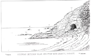
- Sites of Geological and Geomorphological Significance - Site C8 - Red Bluff (James Stirling drawing of Red Bluff (1894))
This information has been developed from the publication:
|
| Location | 03835. At the end of Red Bluff Road, Yanakie. |
Access: | Red Bluff Road. |
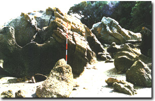
Significant Features: | The site includes Red Bluff and a coastal sector to the east and west. Red Bluff is an active coastal cliff flanked by steep vegetated bluffs. The main cliffed sector is a weathered metamorphosed sedimentary rock now clay rich and with limonite induration. The original rocks appear to be mudstone and fine sandstone but the bedding is indistinct on the eastern side of Red Bluff. On the western side, bedding is more apparent with the beds striking north/south with steep dip. The limonite indurated beds protrude seaward and form small nearshore reefs. There are prominent fractures (both joints and faults) and these are invaded by numerous narrow quartz veins. Three of the larger vertical fractures on the western side have been enlarged by tunnels near the base of the cliff and there are collapsed or covered tunnels on the eastern side as well. It is not apparent whether these are mine adits or weathering/marine erosion features. |
On the eastern side, the sediments are intruded by granite and small tongues of granite extending into the sedimentary rock. The granite is also weathered and is soft and slumping but the contact zone is obvious. Further east, less weathered granite outcrops at the base of the bluff and there are small granite stacks offshore. | |
On the western side of Red Bluff is a broad sandy beach while on the eastern side is a 30 m wide zone of mangroves in front of a narrow sand beach. A sand lobe is extending into the mangrove zone causing zone dieback. There is a broad gap in the mangrove zone where mangroves have been cut and removed to allow boat access from of the several boatsheds along this part of the coast. | |
Significance Level: | State. This is the only site where there is a visible contact between the Wilsons Promontory granites and the invaded Palaeozoic rocks. It is an example of the geological margin of Wilsons Promontory as well as an illustration of thermal metamorphic and weathering alteration of granitic and sedimentary rocks. The age of the Palaeozoic rocks is uncertain and they have been variously described as Silurian (Ferguson 1927), Devonian (Douglas 1972) and Ordovician (Wallis 1981, 1988). It is one of only two Palaeozoic sedimentary rock outcrops in Corner Inlet and forms a distinctive hard rock coastline. The site is accessible and displays a number of very different coastal features. The site was described by Murray (1876) in his pioneering work on the geology of Gippsland. Stirling (1894) provides a drawing of the Red Bluff outcrop showing one of the tunnels. He remarked on the recovery of gold and tin from gravel wash nearby and it is probable that these were tunnel following quartz veins. |
Management Issues: | Access and climbing on the crumbling bluff is difficult. Access from a parking area near the boat sheds east of the site should be developed. The private boat sheds are surely an inappropriate use of Crown Land in a Marine Park and should be removed. It is obvious that they are used for more than just boat storage and they impart an unwarranted image of private ownership on the foreshore. The cutting and removal of mangroves to allow for private boat launching is clearly in breach of good management principles and urgent actions should be undertaken to prohibit the practice and prosecute offenders |
Research & Monitoring Requirements: | Further work on the stratigraphy of the sediments is warranted. It would be of interest to determine the origin of the tunnels. The recovery of previously cut mangroves should be monitored. |
Public Interpretation Possibilities: | The site has excellent possibilities. It is included in the geology excursion guide to Wilsons Promontory by Wallis (1988) to illustrate the granite contact but public interest in the site could be extended to cliffs, beaches, mangroves and coastal erosion and accretion. |
Main References: | Murray, R. A. E. (1876). 'Report on the geology and mineral resources of South-East Gippsland' Geol. Surv. Vict. Report of Progress 3, 135-171. Stirling, J. (1894). 'Report on Agnes River tin mining district'. Geol. Surv. Vict. Report of Progress 8, 70-72. Ferguson, W. H. (1927). Yanakie South geological mapsheet 40 chains to one inch. Geol. Surv. Vict. Wallis, G. (1981). The geology of the Wilsons Promontory batholith, Victoria, MSc thesis, Department of Earth Science, Monash University (unpub). Wallis, G. (1988). 'Wilsons Promontory' in Victorian Geology Excursion Guide, eds I. Clark & B. Cook. |
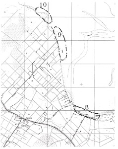 Sites 8, 9, 10 | |
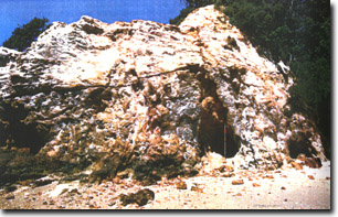 Palaeozoic outcrop on western side of Red Bluff (note the tree tunnels). | 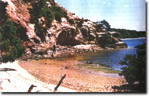 Weathered Palaeozoic on eastern side of Red Bluff. Granite contact is at left of figure |
 Sand lobe moving into mangrove fringe east of Red Bluff | 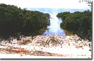 Boat launching ramp cut through mangroves in front of private boat shed east of Red Bluff |
© State of Victoria (Agriculture Victoria) 1996 - 2025.

This work, Victorian Resources Online, is licensed under a Creative Commons Attribution 4.0 licence. You are free to re-use the work under that licence, on the condition that you credit the State of Victoria (Agriculture Victoria) as author, indicate if changes were made and comply with the other licence terms.
The licence does not apply to ‘branding’ or some ‘images or photographs’ that may be owned by third parties. We ask you to seek prior approval to use images using the VRO feedback form. Access to higher quality images can also be provided on request.
This page was last updated on 25/01/2019.