
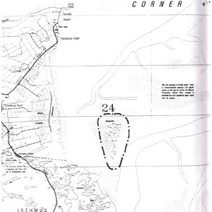
24. Long Island
This information has been developed from the publication:
|
| Location | 385990. Four km SSE of Townsends Point. The island is 1 km offshore of the Yanakie dune coast. |
Access: | Boat access in Bennison Channel or Middle Channel. |
Significant Features: | This marsh island has a limited area of mangrove and features a large number of ponds in the salt marsh. The northern and western shores are in a phase of rapid erosion with extensive shoreline retreat between 1940 and 1984 noted by Vanderzee (1988). |
Significance Level: | Regional. The island is part of an ongoing monitoring programme commenced by Vanderzee (1988). |
Management Issues: | No applicable. |
Research & Monitoring Requirements: | Continuation of the monitoring and mapping programme. |
Public Interpretation Possibilities: | Not appropriate. |
Main References: | Vanderzee, M. P. (1988). 'Changes in saltmarsh vegetation as an early indication of sea-level rise' in Greenhouse: Planning for Climatic Change ed. by G. I. Pearman, CSIRO, Melb. |
© State of Victoria (Agriculture Victoria) 1996 - 2025.

This work, Victorian Resources Online, is licensed under a Creative Commons Attribution 4.0 licence. You are free to re-use the work under that licence, on the condition that you credit the State of Victoria (Agriculture Victoria) as author, indicate if changes were made and comply with the other licence terms.
The licence does not apply to ‘branding’ or some ‘images or photographs’ that may be owned by third parties. We ask you to seek prior approval to use images using the VRO feedback form. Access to higher quality images can also be provided on request.
This page was last updated on 25/01/2019.