
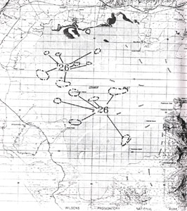
26.Inter-tidal Drainage Patterns
This information has been developed from the publication:
|
| Location: | Various sites are indicated on the accompanying map. |
Access: | All are accessible only by boat and can only be observed at low tide. |
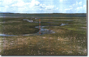
Significant Features: | The sites display different tidal drainage topography on the floor of Corner Inlet. Areas with dense seagrass cover or where seagrass is absent have little topographic variation. However, tidal flats with sparse or intermittent cover develop distinctive drainage patterns. The most widespread pattern is a series of small shallow depressions usually linked by channels. The arrangement of pools and channels is dominantly in a trellis or rectangular pattern. |
Significance Level: | Regional. |
Management Issues: | Channels dug by propellers of stranded boats can change the drainage pattern on inter-tidal flats as noted on Western Port Bay. However, the lower density of boats and the defined nature of the major channel systems make this an insignificant issue in Corner Inlet. |
Research & Monitoring Requirements: | Aerial photo comparisons to determine changes in these patterns and their development as seagrass cover changes is warranted. |
Public Interpretation Possibilities: | The extensive inter-tidal flats of Corner Inlet have the potential to provide rewarding visitor experience and to provide insight into the biological geomorphological complexity of this zone. The vegetated flats are sensitive to trampling and collecting of material (e.g. sponges) exposed at low tide. Detailed study is required to identify sites suitable as visitor sites. |
Main References: | Vertical aerial photographs. |
 Site 26, inter-tidal drainage patterns | 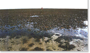 Inter-tidal flat at low tide with Posidonia south of Franklin Channel |
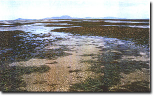 Channel through Posidonia on inter-tidal flat south of Franklin Channel | 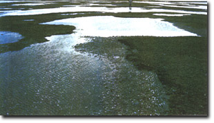 Drainage system on inter-tidal flat with only a light cover of Zostera |
 Incised tidal drainage channel developing on inter-tidal flat |
© State of Victoria (Agriculture Victoria) 1996 - 2025.

This work, Victorian Resources Online, is licensed under a Creative Commons Attribution 4.0 licence. You are free to re-use the work under that licence, on the condition that you credit the State of Victoria (Agriculture Victoria) as author, indicate if changes were made and comply with the other licence terms.
The licence does not apply to ‘branding’ or some ‘images or photographs’ that may be owned by third parties. We ask you to seek prior approval to use images using the VRO feedback form. Access to higher quality images can also be provided on request.
This page was last updated on 25/01/2019.