
11. Ennis’ Bend and the Dead End
This information has been developed from the publication:
|
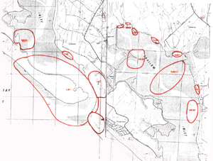
| Location | 264004. The Dead End is the ‘blind’ channel just west of the main channel near the beach car park, and Ennis’ end is the swamp area north of the plain (off-beach) car park. The two features are separated by a scrub-covered sand ridge. |
Access: | From car parks at end of Sandy Point Road. |
Significant Features: | The channel and swamp are remnant former positions of the main Shallow Inlet channel. They developed when the channel had breached the neck of the spit and opened directly to Waratah Bay. The Dead End dates from a breach in 1901, while Ennis’ end is either from that episode or one that occurred during the nineteenth century. |
Significance Level: | Local. The channel and swamp are evidence of substantial movement of the main inlet channel. |
Management Issues: | No manage difficulties are evident. |
Research & Monitoring Requirements: | Not applicable. |
Public Interpretation Possibilities: | Not applicable. |
Main Reference: | Smith, A. S. (1969). 'The geomorphology of Shallow Inlet, Victoria.' B.Sc. (Hons) Thesis. Dept. of Geography. Univ. of Melb. |
© State of Victoria (Agriculture Victoria) 1996 - 2025.

This work, Victorian Resources Online, is licensed under a Creative Commons Attribution 4.0 licence. You are free to re-use the work under that licence, on the condition that you credit the State of Victoria (Agriculture Victoria) as author, indicate if changes were made and comply with the other licence terms.
The licence does not apply to ‘branding’ or some ‘images or photographs’ that may be owned by third parties. We ask you to seek prior approval to use images using the VRO feedback form. Access to higher quality images can also be provided on request.
This page was last updated on 25/01/2019.