
12. Tea-Tree Point & Tea-Tree Island
This information has been developed from the publication:
|
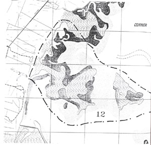
| Location | 120305. Tidal peninsula and island north of Golden Creek Bight. |
Access: | Only accessible across private property from Fullers Road. |
Significant Features: | This is a large site which is mainly tidal wetland with mangrove, salt marsh, saline ponds and small areas of Melaleuca swamp. Tea-Tree Point is a low peninsula almost entirely surrounded by mangroves and submerged a high spring tide. Behind the mangrove is an extremely flat surface which is a mosaic of salt marsh (mainly Sarcocornia) and bare sandy saline flats. Tidal drainage is poorly developed with a small number of main tidal creeks crossing the main mangrove zones but very few tributaries. Large areas of saline flat have no defined drainage direction. There are several circular ponds in the Sarcocornia, the largest being 40 m diameter. In the north-east is an isolated stand of Melaleuca on a higher sandy ridge. Tea-Tree Island is 500 m to the east and has a similar topographic, tidal and vegetation pattern (although it appears to lack Tea-Tree and Melaleuca). The north-eastern side of Tea-Tree Island is sandy with few mangroves. Extending east from the island is a sand shoal with relict tidal drainage features indicating the area of the island has been reduced by submergence and erosion. |
Significance Level: | State. The site is an example of marsh island formation due to subsidence (Vanderzee 1988). Aerial photographic comparison shows mangroves to be extending "upstream" along tidal creeks suggesting increasing tidal submergence and tidal channel formation. The mangrove zone, while often eroding on the outer edge with only mature plants and few seedling and juveniles appears to be spreading towards the centre of Tea-Tree Point and invading Sarcocornia zones. This pattern of spread and the associated physiographic changes (erosion, tidal creek development) are a probably indication of continuing submergence or relative sea level rise. The site has been quoted as providing a model of mangrove/salt marsh response to a rising sea level (Vanderzee 1988). |
Management Issues: | Salt marsh and saline flats are fragile and severely damaged by trampling. This is a scientific site rather than a visitor site and public access should not be encouraged. This is one of the few sites on the western and northern coast of Corner Inlet where the immediate coastal hinterland has not been greatly modified by drainage or embankments. Drainage and reclamation of the landward edge should not be permitted. |
Research & Monitoring Requirements: | Control sites to be established to monitor mangrove/salt marsh changes. Precise levelling of topography to be used as basis for long term comparisons of tidal submergence and observations of sea level change. |
Public Interpretation Possibilities: | Not applicable (see Management Issues above). |
Main References: | Jenkin, J.J. (1968). 'The Geomorphology and Upper Cainozoic Geology of South-East Gippsland.' Geological Survey of Victoria, Memoir 27. Vanderzee, M. P. (1988). 'Changes in saltmarsh vegetation as an early indication of sea-level rise' in Greenhouse: Planning for Climatic Change ed. by G. I. Pearman, CSIRO, Melb. |
 Site 12 | 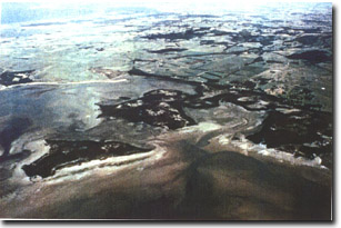 Aerial oblique photograph of Tea Tree Point |
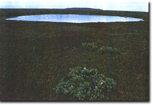 Large saline pond in Sarcocornia marsh at Tea Tree Point | 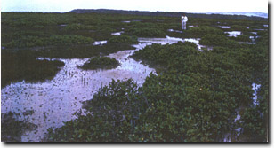 Mangrove spreading across saltmarsh at Tea Tree Point |
© State of Victoria (Agriculture Victoria) 1996 - 2025.

This work, Victorian Resources Online, is licensed under a Creative Commons Attribution 4.0 licence. You are free to re-use the work under that licence, on the condition that you credit the State of Victoria (Agriculture Victoria) as author, indicate if changes were made and comply with the other licence terms.
The licence does not apply to ‘branding’ or some ‘images or photographs’ that may be owned by third parties. We ask you to seek prior approval to use images using the VRO feedback form. Access to higher quality images can also be provided on request.
This page was last updated on 25/01/2019.