
15. Franklin Island
This information has been developed from the publication:
|
| Location | 365165. The island is on the western side of the Franklin River tidal channel 1 km south of Port Franklin. |
Access: | Boat access only at high tide. |
Significant Features: | Franklin Island is a large marsh island drained by three tidal creek systems and with a central salt marsh. There is a small Melaleuca zone in the north and two remnant stands on the eroding western coast. Large shell banks have accumulated in the intertidal zone on the south-western coast. The largest tidal creek system draining to the south is a relatively complex one with three groups of channels and tributaries. There are several large ponds in the salt marsh zone. By comparing aerial photographs taken between 1941 and 1984, Vanderzee (1988) noted a marked reduction in the area of Melaleuca and a landward migration of the mangrove zone. This indicates a continuing relative sea level rise. |
Significance Level: | Regional. The site is one of the largest and least modified mangrove and salt marsh system in Corner Inlet. It illustrates continuing ecological and physiographic change. |
Management Issues: | The site is not threatened by present land use. Any dredge spoil resulting from deepening of the Franklin Channel should not be disposed on the site. |
Research & Monitoring Requirements: | Establish permanent mapping transects to determine ongoing physiographic and ecological change. |
Public Interpretation Possibilities: | Access is very difficult and increased traffic will damage the sensitive salt marsh zone. Increased access could only be arranged by providing elevated boardwalks and ramps. |
Main References: | Vanderzee, M. P. (1988). 'Changes in saltmarsh vegetation as an early indication of sea-level rise' in Greenhouse: Planning for Climatic Change ed. by G. I. Pearman, CSIRO, Melb. |
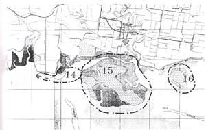 Sites 14 (Foster Beach), 15 (Franklin Island) and 16 (Long Point) | 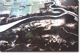 Aerial oblique photograph of Franklin Island |
© State of Victoria (Agriculture Victoria) 1996 - 2025.

This work, Victorian Resources Online, is licensed under a Creative Commons Attribution 4.0 licence. You are free to re-use the work under that licence, on the condition that you credit the State of Victoria (Agriculture Victoria) as author, indicate if changes were made and comply with the other licence terms.
The licence does not apply to ‘branding’ or some ‘images or photographs’ that may be owned by third parties. We ask you to seek prior approval to use images using the VRO feedback form. Access to higher quality images can also be provided on request.
This page was last updated on 25/01/2019.