
3. Millers Landing
This information has been developed from the publication:
|
| Location | 395933. Coast at and east of Millers Landing, Wilsons Promontory National Park. |
Access: | Five Mile Road and Millers Landing Track. |
Significant Features: | Granites outcrop at the coast and as islets, rock stacks and a low tide tombolo. Weathered granite just east of Millers Landing forms a smooth, gently sloping shore platform with a scattering of small boulders and rock stacks. Some of the stacks form miniature “old hat” platforms. There are varied weathering patterns on the granite with examples of coarse tafoni, corestone isolation and development of small overhanding and flared slopes. Mangroves grow among the boulders and on mud deposited on the shore platform. The main group of boulders offshore from Millers Landing form a low tide tombolo. Eroding peat and swamp sediments and undercutting of Melaleuca just to the east are evidence that this was a more permanent tombolo that has recently been breached. |
There is an unusual growth pattern in mangroves near Millers Landing. A broad zone of mature mangrove has an abrupt landward margin and is succeeded by an even-aged stand of much younger mangroves that appear to be spreading landward toward a peat terrace and Melaleuca stand. Further east, there is a compressed succession of mangroves, sedgeland, unvegetated pools and freshwater swamp. The mangroves are spreading into the sedgeland zone. The mangroves at this site are the most southerly in Australia. | |
Significance Level: | State. The site is significant for the collection of coastal granite weathering features and particularly for the mangrove/sedgeland/freshwater swamp interface. The spread of mangrove landward into freshwater areas is an illustration of the response of coastal saltmarsh communities to a rise in sea level as modelled by Vanderzee (1988). This is also one of the only three recorded sites on the Victorian coast where mangroves are flourishing on a rocky shoreline. |
Management Issues: | No coastal structures or channel dredging should be undertaken. |
Research & Monitoring Requirements: | Permanent transects to monitor changes in mangrove distribution, sea level and coastal stability. |
Public Interpretation Possibilities: | The eastern end of the site is robust and would be suitable for interpretation to explain the nature of coastal weathering and the significance of the vegetation boundaries. There are problems of vegetation damage if visitor pressure in the wetlands was greatly increased. |
Main References: | Vertical aerial photographs |
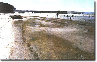 Granite platform and tombolo, Millers Landing | |
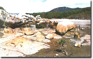 Corestones and tafoni on granite platform at Millers Landing | 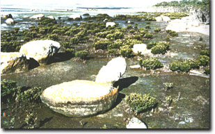 Mangroves and boulders east of Millers Landing |
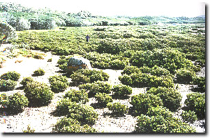 Young mangroves spreading inland behind nature mangrove fringe at Millers Landing | 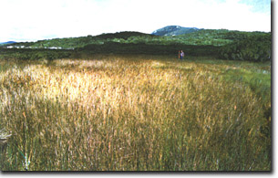 Mangrove and sedgeland east of Millers Landing |
© State of Victoria (Agriculture Victoria) 1996 - 2025.

This work, Victorian Resources Online, is licensed under a Creative Commons Attribution 4.0 licence. You are free to re-use the work under that licence, on the condition that you credit the State of Victoria (Agriculture Victoria) as author, indicate if changes were made and comply with the other licence terms.
The licence does not apply to ‘branding’ or some ‘images or photographs’ that may be owned by third parties. We ask you to seek prior approval to use images using the VRO feedback form. Access to higher quality images can also be provided on request.
This page was last updated on 25/01/2019.