
1. Chinaman Creek Delta
This information has been developed from the publication:
|
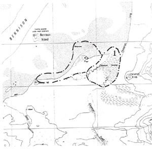
| Location | 485992. Mouth of Chinaman Creek at the southern end of Chinaman Long each, Wilsons Promontory National Park |
Access: | Walk from Tin Mine Track. Small boat access possible at high tide and the creek is navigable for some distance. |
Significant Features: | Chinaman Creek crosses a long swamp zone (Chinaman Swamp) between Barrys Hill and Chinaman Knob and flows into Corner Inlet at the southern end of Chinaman Long Beach. The lower reaches are deltaic and tidal and the channel is fringed by a wide zone of mangrove, salt marsh and brackish water swamp. The delta has infilled a former embayment and has a deltaic extension 2 km long across this. The palaeodrainage and the stages of embayment reclamation are complex and would form the basis for a detailed research project. Two major palaeochannels are evident on aerial photographs indicating earlier stages of creek mouth and delta development. The growth of the delta is related to elongate spit north from near Barrys Hill, which partly enclosed the embayment at the creek mouth and allowed deltaic accumulation. Several episodes of an en echelon spit development are evident e.g. aerial photograph (Film 3827, 18-3-1983 Corner Inlet Project 1713 Run 19 Frames 26-28). |
The creek mouth is lined by a thick zone of mangrove and thin, intermittent mangrove fringe persists for almost 1 km upstream. A small number of tidal creeks cross the salt mars covered deltaic plain. Numerous stumps and dead stalks across the plain indicate a recent dense cover of Melaleuca which has been killed by fire, waterlogging or increased salinity due to greater tidal flooding. | |
Significance Level: | State. The site is a major deltaic feature and illustrates a number of issues in environmental change. |
Management Issues: | Given the remote and relatively inaccessible locality in a national park, the site is not regarded as threatened. |
Research & Monitoring Requirements: | The analysis of delta growth given above is speculative as there is no detailed research into the chronology or mechanism of delta and swamp development. There are major research issues here in Holocene stratigraphy and current recent environmental change – especially changes in hydrology and salinity of the deltaic plain. |
Public Interpretation Possibilities: | This is a sensitive wetland site. To allow public participation at the site would require major trackworks, bridging and boardwalks across sensitive areas. Detailed interpretation of freshwater, brackish and saline swamp conditions are possible. |
Main References: | Vertical aerial photographs (Film 3821, 18-3-1983 Corner Inlet Project 1713 Run 19 Frames 26-28}. |
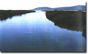 Mangrove-lined channel of Chinaman Creek delta | 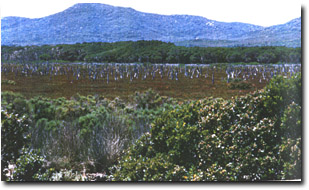 Salt marsh and dead Melaleuca on Chinaman Creek delta |
© State of Victoria (Agriculture Victoria) 1996 - 2025.

This work, Victorian Resources Online, is licensed under a Creative Commons Attribution 4.0 licence. You are free to re-use the work under that licence, on the condition that you credit the State of Victoria (Agriculture Victoria) as author, indicate if changes were made and comply with the other licence terms.
The licence does not apply to ‘branding’ or some ‘images or photographs’ that may be owned by third parties. We ask you to seek prior approval to use images using the VRO feedback form. Access to higher quality images can also be provided on request.
This page was last updated on 25/01/2019.