8. Barrier Ridges - Barry Beach - Welshpool
This information has been developed from the publication:
|
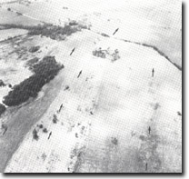
Location: | 490170. North-east of Barry Beach. |  Parallel barrier dunes and swales - Barry Beach to Welshpool. (Arrows indicate trend of ridges and swales.) |
Access: | Barry Beach Road. | |
Ownership: | Private Land. | |
Geology/Geomorphology: | Several low, parallel widely spaced sand ridges trend north-easterly between Welshpool and Barry Beach. The ridges are of beach and wind blown sands and show leaching and ferruginisation in their upper sections grading to less weathered yellow to orange sand deeper in the profile. Depressions between the dunes are swamps or drained swamps where the leached sands are overlain by darker organic material. The ridges and depressions are remnants of the barrier system that can be traced from Barry Beach eastward to St. Margaret Island. The barriers are regarded as equivalent to the inner barrier formation of the Gippsland Lakes, e.g. at Sperm Whale Head. | |
Significance: | Regional. The area is a clear example of the inner barrier formation in the Port Welshpool – Port Albert area. | |
Management: | The site covers an extensive area and is unlikely to be seriously affected by localised land disturbance. Extensive levelling of ridges and filling of the depressions would destroy the geomorphologically significant features. | |
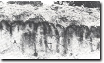
 Older barrier (A), at Barry Beach, overlain by younger dunes. Darker streaks are organic material infilling solution pipes in the older dune deposits. |


