
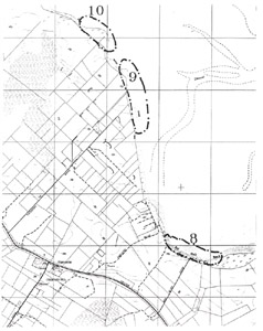
9. The Chalk Cliffs (Patterson Road)
This information has been developed from the publication:
|
| Location | 073324. North and south of Patterson Road, Yanakie. The site name is taken from the description on the Geological Parish Plan (40 chains to 1 inch) by Ferguson and Kenny (1927). None of the geographical features are named on current topographic maps. |
Access: | Patterson Road. There is a public right-of-way at the end of the road to tracks along the cliff top and side-tracks to the beach. |
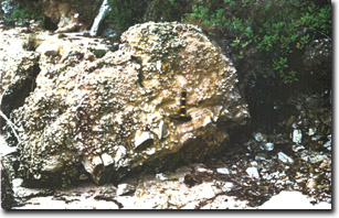
Significant Features: | The coastal cliffs and bluffs have outcrops of Palaeozoic sedimentary rock overlain by cemented Tertiary sands and gravels. There are two major outcrops as active cliffs - the first directly at the end of Patterson Road and the second 600 m to the north - and several partly obscured exposures on adjacent bluffs. Ferguson (1927) applied the name "The Chalk Cliffs" to the northerly outcrop, presumably because of the soft white nature of the mudstone. The rocks are similar to the altered sedimentary beds at Red Bluff but have been less affected by metamorphism and weathering. There is no chalk but the main material is grey and white mudstone with numerous thin quartz veins. The beds are faulted but have a distinct northerly strike and Ferguson (1927) described the outcrop as a syncline with northerly plunge. The syncline is best observed in sea level shore platform outcrops and reefs of harder rock occur up to 150 m offshore. There are a number of faults and joints including close-spaced bedding faults either limonite filled or invaded by quartz veins. A number of small tunnels similar to those at Red Bluff follow these fractures. The rocks are Lower Palaeozoic sediments (either Ordovician or Devonian as at Red Bluff). The Palaeozoic rocks outcrop in the coastal bluff for 500 m west of the main cliffs. |
Extending north-west from these cliffs is a smooth, level, wide shore platform with a veneer of coarse, angular gravels and boulders. The platform is cut in the Palaeozoic sedimentary rocks but the gravels are derived from disintegration of Tertiary Haunted Hill Formation sediments that cap the Palaeozoic rocks. Large blocks of this material lie on the beach north of The Chalk Cliffs and include some very coarse breccias (angular conglomerates) with large clasts of quartz, feldspar and broken dyke rock (aplite?). | |
The southern cliffs are of similar Palaeozoic geology and include slates as well as mudstone beds. There is a striking angular unconformity with cemented Haunted Hills Formation gravels exposed on a 10 m high cliff. At the boundary of these formations is an unusual weathering junction that is not exposed at any other locality in the study area. | |
Significance Level: | State. The site is an excellent teaching and display site and presents interesting research issues. This is the most extensive Palaeozoic sedimentary rock exposure in Corner Inlet and a rare example of an unconformity with the Haunted Hills Formation. Unconformities are important geological boundaries and this an unusual contact with some challenging issues in interpretation. The gravels covering the shore platform are also an uncommon facies and are an excellent example of beach sediment derivation. The reasons for the width and smoothness of the shore platform are not apparent. There is a also a low sandy beach terrace between the two cliffs which is of significance. |
Management Issues: | Access needs to be formalised as do parting and tracks in the coastal scrub. The geological sites are generally not threatened, however, indiscriminate rubbish disposal (from an adjoining farm property?) above the southern cliffs is unsightly and dangerous. |
Research & Monitoring Requirements: | The stratigraphy of the Palaeozoic rocks has yet to be determined. The nature and source of the gravels wet of cliff 2 is an interesting research issue. Transects to monitor changes in profile and vegetation on the beach terrace north of cliff 2 would be of interest. |
Public Interpretation Possibilities: | Good possibilities. The site is accessible, robust and has a variety of features of interest. A combination of cliff top and beach trails could be developed between here and Red Bluff and be extended to Charles Hall Road to link with sites 11 and 12. |
Main References: | Ferguson, W. H. & Kenny, J. P. L. (1927). Yanakie, Waratah North, Toora, Wonga Wonga North geological mapsheets 40 chains to one inch, Geol. Surv. Vict. |
 Sites 8, 9, 10 | 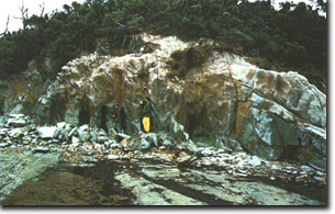 Palaeozoic outcrop at The Chalk Cliffs. Note the narrow tunnels similar to those at Red Bluff and the shore platform in front of the cliffs. |
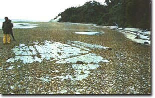 Wide shore platform with a veneer of gravel from Haunted Hill Formation extending west from The Chalk Cliffs. | 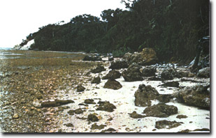 Blocks of Haunted Hill Formation gravel on shore platform west of The Chalk Cliffs |
 Coarse blocks and silcrete? in Haunted Hill Formation Gravel west of The Chalk Cliffs | 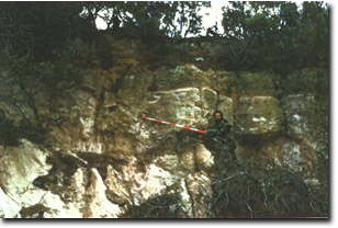 Detail of unconformity |
© State of Victoria (Agriculture Victoria) 1996 - .

This work, Victorian Resources Online, is licensed under a Creative Commons Attribution 4.0 licence. You are free to re-use the work under that licence, on the condition that you credit the State of Victoria (Agriculture Victoria) as author, indicate if changes were made and comply with the other licence terms.
The licence does not apply to ‘branding’ or some ‘images or photographs’ that may be owned by third parties. We ask you to seek prior approval to use images using the VRO feedback form. Access to higher quality images can also be provided on request.
This page was last updated on .