
18. Toora Island
This information has been developed from the publication:
|
| Location | 432177. One km north-east of Toora Beach. |
Access: | Boat access from Mangrove Channel off Toora Channel. |
Significant Features: | This is a small mangrove and salt marsh island 200 m in diameter surrounded by a broad area of sandy inter-tidal flat. The salt marsh core is exposed on the southern side as the mangroves have been eroded away and there is mangrove die-back on the east of the island. In part the die-back may have been initiated by a sand chenier being driven across the mangroves smothering the pneumatophores and preventing regeneration. A sand wedge is penetrating along the eastern side but sand has dispersed along the southern coast eastern side but sand has dispersed along the southern coast where there low eroding cliffs in salt marsh peat. The island has the appearance of having recently been truncated with the loss of about 30% of the mangrove and salt marsh area. In February 1989 there was a very dense cover of mangrove seedling in gaps in the mangrove fringe on the eastern side of the island and on the sheltered north coast. |
Significance Level: | Regional. The erosion pattern is similar to that at Toora Beach and Foster Beach. This is one of the most rapidly changing islands in Corner Inlet. |
Management Issues: | No action is required at the site. |
Research & Monitoring Requirements: | The rate and time of onset of erosion could be determined from aerial photograph comparison. Base lines to allow regular comparative mapping to determining current erosion rates should be established. |
Public Interpretation Possibilities: | Toora Island is one of the more safely accessible marsh islands and could be used as an example of such. |
Main References: | Vertical aerial photographs. |
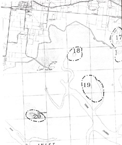 Sites 17 (Agnes River), 18 (Toora Island), 19 (Inter-tidal flats) and 20 (Mangrove Island) | 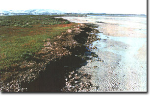 Eroding southern margin of Toora Island |
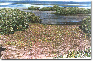 Intensive growth of mangrove seedlings on Toora Island (March 1989) |
© State of Victoria (Agriculture Victoria) 1996 - .

This work, Victorian Resources Online, is licensed under a Creative Commons Attribution 4.0 licence. You are free to re-use the work under that licence, on the condition that you credit the State of Victoria (Agriculture Victoria) as author, indicate if changes were made and comply with the other licence terms.
The licence does not apply to ‘branding’ or some ‘images or photographs’ that may be owned by third parties. We ask you to seek prior approval to use images using the VRO feedback form. Access to higher quality images can also be provided on request.
This page was last updated on .