
3. Active High Dune Ridges near Blue Lagoon
This information has been developed from the publication:
|
| Location | 300985 Eastern side of Shallow Inlet 1 km south-east of Warren Lane (off Millar Road, Yanakie). | 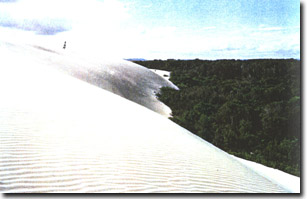 Massive precipitation ridge - eastern shore Shallow Inlet |
Access: | Walk from track via Millar Road or from camping ground or boat access. | |
Significant Features: | An unvegetated sand mass comprising two main sand lobes is advancing over former established parabolic dune ridges. The older dune ridges lie at right angles to the shore of Shallow Inlet while the active dune mass is comprised of regular transverse ridges parallel to the inlet shore. The active dunes are gently sinuous and have crests spaced at 10 to 40 metres. The dunes are advancing eastward and terminate in a massive precipitation ridge burying coastal scrub. The dunes are similar in orientation and form to those on the entrance spit but are much higher due to the development of the precipitation ridge upwind of the scrub vegetation. It is of interest that the dune lies opposite the distal end of the entrance spit. | |
Significance Level: | Local. | |
Management Issues: | The major issue is the possible threat the dune poses to adjacent farmland (about 250 metres at closest point). Cecil (1984) measured annual rates of movement averaging 3 metres on parts of the dune but the movement is irregular. The National Parks Division is continuing to monitor dune movement. It can be anticipated that movement will continue but that annual rates will vary. The dune is one element in a long history of aeolian activity on the east of Shallow Inlet and is an important illustration of the process that has shaped much of the terrain on that shore. “Artificial” stabilization by building sand fences and introducing sand-binding grasses should be used only if it can be shown that movement is a hazard to private property. | |
Research & Monitoring Requirements: | Maintenance and analysis of monitoring stations to determine rates and times of movement of the dune crest and toe. Comparison of these rates with other parameters of the dune e.g. size of sand catchment, height of dune, nature of fronting vegetation. Evaluation of early aerial photographs for comparison of movement rates. | |
Public Interpretation Possibilities: | Not applicable. | |
Main References: | Cecil, M. K. (1983). 'The evolution of the entrance to Shallow Inlet.' Geol. Surv. Vict. Unpub. Rept. 1983/71. | |
 Shallow Inlet (south and north) | 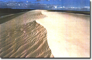 Crest of precipitation ridge, Shallow inlet |
© State of Victoria (Agriculture Victoria) 1996 - 2025.

This work, Victorian Resources Online, is licensed under a Creative Commons Attribution 4.0 licence. You are free to re-use the work under that licence, on the condition that you credit the State of Victoria (Agriculture Victoria) as author, indicate if changes were made and comply with the other licence terms.
The licence does not apply to ‘branding’ or some ‘images or photographs’ that may be owned by third parties. We ask you to seek prior approval to use images using the VRO feedback form. Access to higher quality images can also be provided on request.
This page was last updated on 25/01/2019.