
9. Pleistocene Shoreline Scarp
This information has been developed from the publication:
|
Location: | 535195. Two kilometres south-east of Welshpool. | 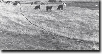 Low scarp (dotted) marking Pleistocene shoreline - Welshpool. |
Access: | Telegraph Road, Rossiters Road. | |
Ownership: | Private Land. | |
Geology/Geomorphology: | This site includes two low escarpments which are probably relict and degraded former sea cliffs. They indicate the sea level during the last interglacial high sea level phase (approximately 100,000 years ago) and may represent the maximum limit of Pleistocene submergence of the South Gippsland coastal area. | |
Significance: | Regional. Although these are inconspicuous features, they are of considerable importance in defining the Pleistocene sea level history of Gippsland. | |
Management: | The scarps are unlikely to be seriously affected by localised land disturbance but extensive construction or earthmoving works would obviously obscure this minor change in relief. | |
© State of Victoria (Agriculture Victoria) 1996 - 2025.

This work, Victorian Resources Online, is licensed under a Creative Commons Attribution 4.0 licence. You are free to re-use the work under that licence, on the condition that you credit the State of Victoria (Agriculture Victoria) as author, indicate if changes were made and comply with the other licence terms.
The licence does not apply to ‘branding’ or some ‘images or photographs’ that may be owned by third parties. We ask you to seek prior approval to use images using the VRO feedback form. Access to higher quality images can also be provided on request.
This page was last updated on 25/01/2019.