Your gateway to a wide range of natural resources information and associated maps

Victorian Resources Online

Sites of Geological and Geomorphological Significance - Bacchus Marsh - Regional, Local

Back to: Port Phillip & Westernport - Sites of Geological and Geomorphological Significance

This is a clickable map. Click on Site in Legend for more information.
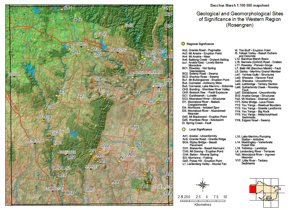
Sites of Geological and Geomorphological Significance - Bacchus Marsh - Regional, Local

Sites of Geological and Geomorphological Significance - Bacchus Marsh, Regional and Local
Regional Significance
An2 Granite Road - PegmatiteI4 The Bluff - Eruption point
An3 Mt Anakie - Eurption pointI5 Yaloak valley - Basalt outliers and dolomite
An4 Mt Anakie - MaarL12 Bacchus Marsh basin
An6 Balliang Creek - Dryland saltingL16 Nerowie (Exford) Road - Craters
An7 Anakie East - Lovely Banks monoclineL17 Rowsley - Parwan Gorge
BC1 Rowsley - Hot spring depressionsL7 Bald Hill (Bacchus Marsh) - Fault
BC2 Swamp Road - SwampL9 Darley - Merrimu gravel member
BC3 Sharkey Road - SwampLet1 Yankee Gully - Structures
Bu1 Mt Bullengarook - Eruption pointLet2 Sheoaks - Hanover Fault
Bu4 Coimadai - Antimony mineLet3 Sheoaks - Unconformity
Bu5 Coimadai - Lake Merrimu - DolomiteLet4 Lethbridge - Tertiary section
CH2 Bunding - Werribee River valleyLet6 Sutherlands Creek - Rowsley Fault
CH5 Bostock Res. - Fault exposureLet7 Donaldsons - Unconformity
EC1 Durdiwarrah - LunetteSV2 Anakie Gorge - Structures
EC3 Moorabool River - StructuresYY1 Kirks Bridge - Lava flows
El1 Moorabool River - Ballark conglomeratesYY2 You Yangs - Residual boulders
El4 Morrisons - Isolated SpurYY3 You Yangs - Granite landforms
El5 Moorabool River - Abandoned meanderYY4 You Yangs - Big Rock
Gd3 Mt Blackwood - Eruption pointYY5 You Yangs - Metamorphised sediments
Gd5 Werribee River - KnickpointYY6 - Edgars Road - swamp
I3 Spring Creek - Fault
Local Significance
An1 Anakie - UnconformityL10 Lake Merrimu Pumping station - Anticline
An5 - Granite road - Granite ridgeL14 Maddingly - Vertebrate fossil site
BC4 Ripley Bridge - Basalt pavementL18 Tabletop - Landslips
CH1 - Blakeville - Basalt remnantL4 Lerderderg River - Terraces
CH3 Mt Gorong - Eurption pointYa3 Moorabool River - Ingrown meander
CH4 Ballan - Mineral SpringYY7 Little River - Tertiary sediments
El3 Morrisons - Folding
Gd2 Pykes Hill - Eruption Point
L1 Lerderderg Valley - Alluvial fan
Page top