
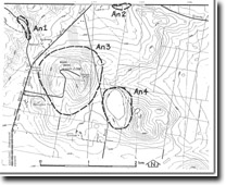
An4 - Mt Anakie - Maar
|
This information has been developed from this publication:
|
| Location: | Anakie - 605026. Shire of Corio. Between Mount Anakie and unnamed central cone immediately east of road. | 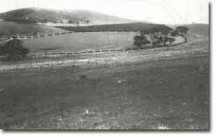 Mt Anakie - Maar |
Access: | Unnamed road linking Staughton Vale Road and Browne Road. | |
Ownership: | Private land. | |
Site Description: | An oval shaped depression approximately 700 m by 400 m is surrounded by a rim of scoria and volcanic ash. The depression floor is swamp and may at times have contained a lake. The depression is the only defined eruption point crater in the Anakie group, as the others have been covered by the last ejections of scoria. | |
Significance: | Regional. This is the only example of a maar in the study area and one of the best preserved volcanic craters on the Werribee lava plains. | |
Management: | Class 1. The site should be protected from disturbance and major quarrying activities should not be permitted. Limited extraction of surface materials or excavation for dams for agricultural purposes only by the property owner could be permitted. It should be a condition on the quarry operator of the central cone that no material in the site be removed or covered by quarry spoil. | |
 Site - An4 |

© State of Victoria (Agriculture Victoria) 1996 - .

This work, Victorian Resources Online, is licensed under a Creative Commons Attribution 4.0 licence. You are free to re-use the work under that licence, on the condition that you credit the State of Victoria (Agriculture Victoria) as author, indicate if changes were made and comply with the other licence terms.
The licence does not apply to ‘branding’ or some ‘images or photographs’ that may be owned by third parties. We ask you to seek prior approval to use images using the VRO feedback form. Access to higher quality images can also be provided on request.
This page was last updated on .