
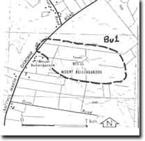
Bu1 - Mt Bullengarook - Eruption Point
|
This information has been developed from this publication:
|
| Location: | Bullengarook - 775458 and Bullengarook - 782455. Shire of Gisborne. Cutting on eastern side of Bacchus Marsh to Gisborne road 11 km south of Gisborne, and the summit of Mount Bullengarook, east of the Bacchus Marsh to Gisborne Road. | |
Access: | Bacchus Marsh to Gisborne Road. | |
Ownership: | Crown land and private land. | |
Site Description: | The road cuttings expose the basement Ordovician sediments overlain by the lowermost lava flow materials. The volcanics include scoria agglomerate with blocks derived from the Ordovician bedrock. One band of agglomerate is composed almost entirely of slate, sandstone and quartz blown from the Ordovician bedrock by the volcano during eruption. The summit is a scoria mound composed of scoria, tuff and agglomerate with some basalt. | |
Significance: | Regional. The site is a clear example of erupted materials overlying bedrock. The agglomerate band composed of Ordovician sediments makes an interesting field problem for students. The eruption point is a prominent rounded landscape feature that contrasts with the linear ridges of the surrounding Lerderderg Ranges and Gisborne Highlands. It is the source of a lava flow that extends over 20 km to the south and fills the ancient Bullengarook valley. Scoria accumulations of this size are unusual in the study area. | |
Management: | Class 2. The cutting is becoming overgrown and covered with slumped material. To maintain the clarity of the section it will be necessary to occasionally grade or cut back the slope to remove these materials. Any road maintenance operations should be designed to retain the significant exposures. Provision of public access to the summit is desirable to allow a view of the lava flow and the adjacent ranges. This would give an appreciation of the processes that have lead to the inversion of topography and the development of the twin lateral valleys of Pyrites and Goodmans Creeks. | |

© State of Victoria (Agriculture Victoria) 1996 - 2025.

This work, Victorian Resources Online, is licensed under a Creative Commons Attribution 4.0 licence. You are free to re-use the work under that licence, on the condition that you credit the State of Victoria (Agriculture Victoria) as author, indicate if changes were made and comply with the other licence terms.
The licence does not apply to ‘branding’ or some ‘images or photographs’ that may be owned by third parties. We ask you to seek prior approval to use images using the VRO feedback form. Access to higher quality images can also be provided on request.
This page was last updated on 23/11/2018.