
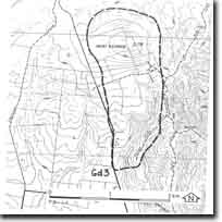
Gd3 - Mt Blackwood - Eruption Point
|
This information has been developed from this publication:
|
| Location: | Greendale - 668399. Shire of Ballan, 7 km north of Myrniong. | |
Access: | Mount Blackwood Road. | |
Ownership: | Private land. | |
Site Description: | Mount Blackwood is the highest volcano in the study area with a summit elevation of 736 m. It is similar in form to Mount Bullengarook although it lacks the extensive accumulation of scoria around the summit. The volcano erupted in a hilly area of Ordovician rocks and gave rise to lava flows extending to the south, probably filling a former valley. The flow has been dissected and twin lateral stream have developed - Myrniong Creek to the west and Korkuperrimul Creek to the east. The surface of the lava flow slopes steeply where it crosses the line of the Coimadai Fault. | |
Significance: | Regional. The site includes the summit of the mountain and part of the lateral stream to the east. It is an illustration of the development of relief and drainage pattern determined by volcanicity. The Mount Blackwood summit provides an unequalled vantage point to view the Blackwood Ranges, Mount Macedon, Pentland Hills, and the terrain features of the catchment of the Werribee River. | |
Management: | Class 3. The site requires a relatively large area to be maintained to show the relationship between the eruption point. This is best achieved by continuing the present pattern of rural land use. Public road or walking access should be provided to the summit of Mount Blackwood and an un-structured viewing point maintained. | |

© State of Victoria (Agriculture Victoria) 1996 - .

This work, Victorian Resources Online, is licensed under a Creative Commons Attribution 4.0 licence. You are free to re-use the work under that licence, on the condition that you credit the State of Victoria (Agriculture Victoria) as author, indicate if changes were made and comply with the other licence terms.
The licence does not apply to ‘branding’ or some ‘images or photographs’ that may be owned by third parties. We ask you to seek prior approval to use images using the VRO feedback form. Access to higher quality images can also be provided on request.
This page was last updated on .