
L10 - Lake Merrimu Pumping Station - Anticline
|
This information has been developed from this publication:
|
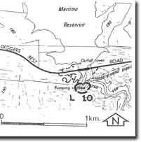
| Location: | Lerderderg - 787315. Shire of Bacchus Marsh. Valley of Pyrites Creek immediately south of the Lake Merrimu Pumping Station. | 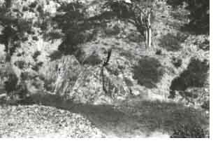 Lake Merrimu Pumping Station - Anticline |
Access: | Coimadai - Diggers Rest Road. | |
Ownership: | Crown land. | |
Site Description: | Outcropping on the south bank of the Pyrites Creek is a symmetrical anticline in Ordovician sandstones and slates. The fold is 5 m high and occurs at the base of a truncated spur. | |
Significance: | Local. The fold is a very clear example of the meso scale deformation structures in the Palaeozoic basement rocks of the Bacchus Marsh area. | |
Management: | Engineering and water conservation structures associated with Lake Merrimu should be designed to avoid damage or obscuration of the folded structure. Access to the site is currently restricted by these works. | |
 Site - L10 |

© State of Victoria (Agriculture Victoria) 1996 - .

This work, Victorian Resources Online, is licensed under a Creative Commons Attribution 4.0 licence. You are free to re-use the work under that licence, on the condition that you credit the State of Victoria (Agriculture Victoria) as author, indicate if changes were made and comply with the other licence terms.
The licence does not apply to ‘branding’ or some ‘images or photographs’ that may be owned by third parties. We ask you to seek prior approval to use images using the VRO feedback form. Access to higher quality images can also be provided on request.
This page was last updated on .