
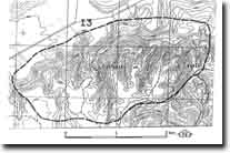
I3 - Spring Creek - Fault
|
This information has been developed from this publication:
|
| Location: | Ingliston - 620203. Shire of Bacchus Marsh. Valley of Spring Creek, 2 km south of Glenmore. | |
Access: | Brisbane Ranges Road. | |
Ownership: | Crown land and private land. | |
Site Description: | Spring Creek Fault delineates the southern boundary of the Ballan Graben. To the south of the fault, Ordovician sedimentary rocks from the Brisbane Ranges, while to the north the Ordovician is buried by a complex of Cainozoic volcanics and sediments. Spring Creek has cut a deep valley, initially parallel to and then crossing the fault, although the stream course is lateral to the lava that caps the Ballan Plateau south of The Bluff. This lava forms an escarpment on the northern side of the valley. Magnesite nodules occur in Tertiary lacustrine clay of the Werribee Formation beneath the basalt. | |
Significance: | Regional. The site includes a major tectonic and physiographic feature of the Bacchus Marsh district. | |
Management: | Class 2. The site should be maintained in its present use as public open space and rural land use. | |

© State of Victoria (Agriculture Victoria) 1996 - .

This work, Victorian Resources Online, is licensed under a Creative Commons Attribution 4.0 licence. You are free to re-use the work under that licence, on the condition that you credit the State of Victoria (Agriculture Victoria) as author, indicate if changes were made and comply with the other licence terms.
The licence does not apply to ‘branding’ or some ‘images or photographs’ that may be owned by third parties. We ask you to seek prior approval to use images using the VRO feedback form. Access to higher quality images can also be provided on request.
This page was last updated on .