
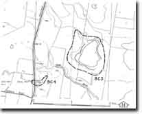
BC3 - Sharkey Road - Swamp
|
This information has been developed from this publication:
|
| Location: | Balliang Creek - 715-75. Shire of Corio. 800 m north of Little River and 1.5 km south of Sharkey Road. | |
Access: | Sharkey Road. | |
Ownership: | Private land. | |
Site Description: | An irregularly-shaped lake has formed in an internal drainage depression created by the intersection of lava flows north of Little River. The lake is fed by a shallow channel from the northwest and deepens towards the southeastern corner. A substantial amount of sediment has accumulated in the lake and built a narrow terrace on the eastern shoreline. The lake is a substantial wetland and must be fed by groundwater as well as surface drainage. | |
Significance: | Regional. The wetland is one of the largest natural semi-permanent water bodies on the Werribee lava plains. It illustrates the complexity of landforms and hydrology of the lava plains. | |
Management: | Class 1. The wetland should be maintained in its present state without artificial reclamation. | |

© State of Victoria (Agriculture Victoria) 1996 - .

This work, Victorian Resources Online, is licensed under a Creative Commons Attribution 4.0 licence. You are free to re-use the work under that licence, on the condition that you credit the State of Victoria (Agriculture Victoria) as author, indicate if changes were made and comply with the other licence terms.
The licence does not apply to ‘branding’ or some ‘images or photographs’ that may be owned by third parties. We ask you to seek prior approval to use images using the VRO feedback form. Access to higher quality images can also be provided on request.
This page was last updated on .