
An3 - Mt Anakie - Eruption Point
|
This information has been developed from this publication:
|
| Location: | Anakie - 595032. Shire of Corio. Anakie junction, 3 kilometres north of Anakie township. | 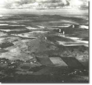 Mt Anakie |
Access: | Ballan Road. | |
Ownership: | Private land. | |
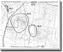
Site Description: | Mount Anakie is the westernmost of a group of three scoria mounds, the central and eastern mounds being unnamed. Although there are broad, shallow basins on the slopes of the three mounds, they are not true craters but have been shaped by an uneven distribution of scoria. Between Mount Anakie and the central mound is an oval-shaped depression which is an eruption point (maar). All four eruption points lie along a straight line, trending southeasterly, possibly related to magma extruding a joint feature or fissure in the underlying granite. The height and steepness of Mount Anakie is due to the large volume of fragmental material (scoria) which has piled up around the northern sides of the vent, producing a broad shallow crater-like opening towards the south. There are abundant fragments (blocks and bombs) on the slopes of Mount Anakie, including rounded bombs with olivine crystals in the centre. Fragments of granite also occur in some scoria bombs and there are reports of some granite fragments weighing several tonnes having been ejected. | |
Significance: | Regional. Mount Anakie is a prominent eruption point and the best (and one of the few) examples of scoria accumulations on the Werribee Plains. The occurrence of granite fragments is unusual in volcanic bombs and blocks, and is a clear illustration that the volcanic vent passes through granitic country rock. The summit of the mountain provides an outstanding panorama of the Rowsley Fault scarp, the You Yangs and the Werribee lava plains. | |
Management: | Class 2. Quarrying should not be permitted on this scoria mound, as there are substantial extractive industry licences available for the two eastern cones of the Anakies. Continuation of present rural land use (grazing and viticulture) is compatible with maintaining the quality of the site. Consideration should be given to permitting public access to the summit, as this provides the best vantage point to view the geological structures and topographic contrasts of the Rowsley Fault scarp, the You Yangs and the Werribee lava plains. | |
 Site - An3 |

© State of Victoria (Agriculture Victoria) 1996 - 2025.

This work, Victorian Resources Online, is licensed under a Creative Commons Attribution 4.0 licence. You are free to re-use the work under that licence, on the condition that you credit the State of Victoria (Agriculture Victoria) as author, indicate if changes were made and comply with the other licence terms.
The licence does not apply to ‘branding’ or some ‘images or photographs’ that may be owned by third parties. We ask you to seek prior approval to use images using the VRO feedback form. Access to higher quality images can also be provided on request.
This page was last updated on 23/11/2018.