
BC2 - Swamp Road - Swamp
|
This information has been developed from this publication:
|
| Location: | Balliang Creek and Staughton Vale - 690116. Shire of Corio. West of Geelong - Bacchus Marsh Road at Swamp Road. | 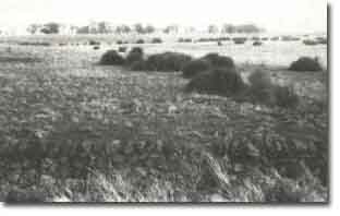 Swamp Road - Swamp |
Access: | Swamp Road. | |
Ownership: | Private land. | |
Site Description: | Between Balliang Creek and Little River is an extensive zone of interrupted drainage where depressions on the lava plain surface have become internal drainage basins. Across Swamp Road there is a broad wetland occupying an elongated basin, the ridge forming the eastern margin being the edge of lava flow. A drystone wall of even-sized basalt boulders on the southern side of Swamp Road indicates this ridge was formerly a stony rise. The wetland has an uneven floor with basalt outcrops and pockets of alluvium. Areas of deeper soil on the basalt ridge probably represent patches of wind-blow alluvium and is associated with an extensive stand of Buloke (Casuarina leuehmannii) on the ridge. The swamps have now been drained and cultivated. | |
Significance: | Regional. The area is a clear example of topography related to drainage disruption, even though the hydrology of the wetland has been substantially disturbed by drainage and cultivation. However, the form of the swamp basin is still distinct and is enhanced by the extensive stand of Buloke. The drystone wall is an excellent example of a form of property boundary that has generally disappeared from the Werribee lava plains. It is a clear indicator of the former extent of stony surfaces on the lava plains. | |
Management: | Class 1. Preservation of the Buloke stand would be facilitated by exclusion of grazing and cultivation from this area. Assistance should be given to property owners to maintain the drystone wall as an effective and significant boundary marker that reflects the nature of the land surfaced before European settlement. | |
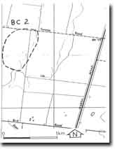 Site - BC2 |

© State of Victoria (Agriculture Victoria) 1996 - .

This work, Victorian Resources Online, is licensed under a Creative Commons Attribution 4.0 licence. You are free to re-use the work under that licence, on the condition that you credit the State of Victoria (Agriculture Victoria) as author, indicate if changes were made and comply with the other licence terms.
The licence does not apply to ‘branding’ or some ‘images or photographs’ that may be owned by third parties. We ask you to seek prior approval to use images using the VRO feedback form. Access to higher quality images can also be provided on request.
This page was last updated on .