
L18 - Tabletop - Landslips
|
This information has been developed from this publication:
|
| Location: | Lerderderg - 697264. Shire of Bacchus Marsh. Northern side of Werribee River, 4 km west of Bacchus Marsh. | 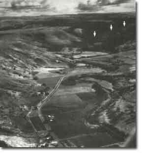 Tabletop - Landslips |
Access: | Werribee Vale Road. | |
Ownership: | Private land. | |
Site Description: | Tabletop hill is capped by a remnant of Newer Volcanics basalt which overlies sediments of the Werribee Formation. The southern hillslope includes an extensive area of mass movement including rotational slumps and earthflows. Other extensive mass movements occur on the opposite valley slope valley above the alluvial floodplain of the Werribee River. | |
Significance: | Local. The site is an example of the extensive mass movement processes which have developed the broad valley of the Werribee River below the Werribee Gorge. | |
Management: | Class 2. The site should be retained as an active mass movement feature and land management should be adapted to take account of the potential hazards of the site. | |
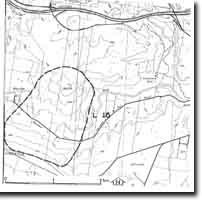 Site - L18 |

© State of Victoria (Agriculture Victoria) 1996 - .

This work, Victorian Resources Online, is licensed under a Creative Commons Attribution 4.0 licence. You are free to re-use the work under that licence, on the condition that you credit the State of Victoria (Agriculture Victoria) as author, indicate if changes were made and comply with the other licence terms.
The licence does not apply to ‘branding’ or some ‘images or photographs’ that may be owned by third parties. We ask you to seek prior approval to use images using the VRO feedback form. Access to higher quality images can also be provided on request.
This page was last updated on .