
L9 - Darley - Merrimu Gravel Member
|
This information has been developed from this publication:
|
| Location: | Lerderderg - 758303. Shire of Bacchus Marsh. Road cutting and disused gravel pit beside Bacchus Marsh to Gisborne road, 1.5 km north of Darley. | 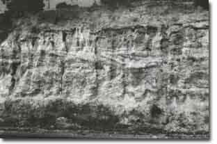 Darley - Merrimu Gravel Member |
Access: | Bacchus Marsh to Gisborne Road. | |
Ownership: | Crown land and some private land. | |
Site Description: | The cuttings expose a gravel, dominated by quartz and sandstone clasts, and beds of medium to coarse sand with some thin beds of white and grey clay. The deposits are clearly cross-bedded and show some ferruginisation. They are designated as the Merrimu Gravel Member of the Werribee Formation. This formation is the major non-marine Tertiary sedimentary material of the study area and the Bacchus Marsh area is the site of its most extensive outcrop. | |
Significance: | Regional. The site is a clear example of a major component of the sedimentary geology of the region and an excellent example of the lithology and structure of a non-marine gravel. | |
Management: | Class 2. Road maintenance procedures should aim at maintaining the clarity of the section. The coherent nature of the gravels obviates the need for artificially stabilizing the exposure which does not present a road way hazard. | |
References: | Roberts P (1984) | |
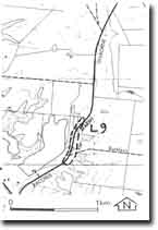 Site - L9 |

© State of Victoria (Agriculture Victoria) 1996 - .

This work, Victorian Resources Online, is licensed under a Creative Commons Attribution 4.0 licence. You are free to re-use the work under that licence, on the condition that you credit the State of Victoria (Agriculture Victoria) as author, indicate if changes were made and comply with the other licence terms.
The licence does not apply to ‘branding’ or some ‘images or photographs’ that may be owned by third parties. We ask you to seek prior approval to use images using the VRO feedback form. Access to higher quality images can also be provided on request.
This page was last updated on .