
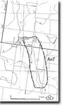
An7 - Anakie East - Lovely Banks Monocline
|
This information has been developed from this publication:
|
| Location: | Anakie - 640960. Shire of Corio. Between Old Boundary road and Carr Road, Anakie East. | |
Access: | Old Boundary Road and Carr Road. | |
Ownership: | Private land and Crown land. | |
Site Description: | Trending south-southeast from the easternmost of the Anakie volcanoes is an east-facing escarpment of the Anakie volcanoes is an east-facing escarpment that is the surface expression of the Lovely Banks Monocline. The monocline is an important tectonic structure delineating the western margin of Port Phillip Sunkland, and east of this line there is a marked reduction in the elevation of the lava plains south of the You Yangs. In the north the monocline is approximately in line with the Anakie volcanoes and may lie along the same fracture plane at depth. At Anakie East, the escarpment is only 10 to 15 m high, but the displacement increases rapidly towards the south so that at Lovely Banks the monocline is a substantial relief feature 70 m high. The most recent movement on the monocline post-dates the eruption of the volcanoes so that lava flows are warped over the monocline scarp. Dissection of the escarpment has exposed the Moorabool Viaduct Formation and Fyansford Clay in small valleys near Lovely Banks. | |
The monocline is here expressed as a gentle escarpment 10 to 15 m high, trending south-south-west from Old Boundary Road. | ||
Significance: | Regional. The monocline is a persistent linear future with increasing expression in the landscape towards the south. It is a clear example of the geomorphological feature determined by a tectonic structure. | |
Management: | Class 2. To maintain the significance of this feature it will be necessary to keep buildings or other obstructive structures away from the crest and slopes so that the displacement can be readily appreciated. This is best achieved by maintaining the area of the escarpment in rural land use or as an open space corridor through built-up land. | |

© State of Victoria (Agriculture Victoria) 1996 - .

This work, Victorian Resources Online, is licensed under a Creative Commons Attribution 4.0 licence. You are free to re-use the work under that licence, on the condition that you credit the State of Victoria (Agriculture Victoria) as author, indicate if changes were made and comply with the other licence terms.
The licence does not apply to ‘branding’ or some ‘images or photographs’ that may be owned by third parties. We ask you to seek prior approval to use images using the VRO feedback form. Access to higher quality images can also be provided on request.
This page was last updated on .