
YY6 - Edgars Road - Swamp
|
This information has been developed from this publication:
|
| Location: | You Yangs - 800985. Shire of Werribee. West of Edgars Road, 3 km north of Little River. | 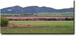 Edgars Road Swamp - looking towards the You Yangs |
Access: | Edgars Road. | |
Ownership: | Private land. | |
Site Description: | This is probably the largest depression on the Werribee lava plain being 1 km long and 500 m wide. The depression has distinct but irregular margins and has no defined inlet or overflow channels. It appears to be a primary depression on the lava surface formed by blocking of drainage by intersecting lava flows. The depression is swampy, filled with small pools of open water and is relatively intact as a physical and botanical system. | |
Significance: | Regional. The site is an example of the initial topography of lava flows, and shows the importance of drainage disruption in developing lava surface features. | |
Management: | Class 1. The site should be maintained intact and not broken up by sub-division or by artificial filling. Residential or industrial building should not be permitted within 100 m of the swamp margin and road works or vehicular crossings of the swamp should be prohibited. | |

© State of Victoria (Agriculture Victoria) 1996 - .

This work, Victorian Resources Online, is licensed under a Creative Commons Attribution 4.0 licence. You are free to re-use the work under that licence, on the condition that you credit the State of Victoria (Agriculture Victoria) as author, indicate if changes were made and comply with the other licence terms.
The licence does not apply to ‘branding’ or some ‘images or photographs’ that may be owned by third parties. We ask you to seek prior approval to use images using the VRO feedback form. Access to higher quality images can also be provided on request.
This page was last updated on .