
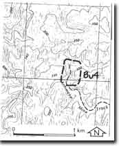
Bu4 - Coimadai - Antimony Mine
|
This information has been developed from this publication:
|
| Location: | Bullengarook - 788401. Shire of Bacchus Marsh. Tributary of Pyrites Creek, 3 km east of Bacchus Marsh - Gisborne Road. | |
Access: | Antimony Mine Track. | |
Ownership: | Crown land. | |
Site Description: | (The site has not been field checked and is based on personal communication from Mr Phil Roberts, Geologist.) The deposit occurs in fault zones of intensely sheared rock in Ordovician bedrock. Two lodes have been worked by shafts and adits now marked by scattered stibnite ore and old mining machinery. | |
Significance: | Regional. The site is the major working antimony occurrences in the Pyrite/Blackwood Ranges. | |
Management: | Class 2. The area should be retained as public land and the geological and industrial evidence of mining allowed to remain. | |
References: | Roberts PS (1984) Bowen KG (1970) Fisher FN (1953) | |

© State of Victoria (Agriculture Victoria) 1996 - 2025.

This work, Victorian Resources Online, is licensed under a Creative Commons Attribution 4.0 licence. You are free to re-use the work under that licence, on the condition that you credit the State of Victoria (Agriculture Victoria) as author, indicate if changes were made and comply with the other licence terms.
The licence does not apply to ‘branding’ or some ‘images or photographs’ that may be owned by third parties. We ask you to seek prior approval to use images using the VRO feedback form. Access to higher quality images can also be provided on request.
This page was last updated on 23/11/2018.