
L4 - Lerderderg River - Terraces
|
This information has been developed from this publication:
|
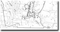
| Location: | Lerderderg - 730317. Shire of Bacchus Marsh. Floodplain of Lerderderg River at ‘Morven” 3 km north of Darley. | |
Access: | Lerderderg Gorge Road. | |
Ownership: | Private land. | |
Site Description: | Three terrace levels occur on the floodplain of the Lerderderg River at ‘Morven’ farm on the northern (left) bank of the stream. The terraces are distinguished by well preserved scarps 1.5 m high. The Lerderderg is cutting into the bank of the lowest terrace exposing gravels, sands and silts of the terrace formation. The river channel at this point has a wide gravel bar developed across the width of the stream channel. | |
Significance: | Local. The terraces are clear examples of these features and are particularly clear when viewed from the high cliff on the opposite (southern) side of the valley. | |
Management: | Class 2. Continuation of rural land use will maintain the form of the terraces. Excavation or building upon this terrain would obscure the significant form of the terraces. | |

© State of Victoria (Agriculture Victoria) 1996 - .

This work, Victorian Resources Online, is licensed under a Creative Commons Attribution 4.0 licence. You are free to re-use the work under that licence, on the condition that you credit the State of Victoria (Agriculture Victoria) as author, indicate if changes were made and comply with the other licence terms.
The licence does not apply to ‘branding’ or some ‘images or photographs’ that may be owned by third parties. We ask you to seek prior approval to use images using the VRO feedback form. Access to higher quality images can also be provided on request.
This page was last updated on .