Your gateway to a wide range of natural resources information and associated maps

Victorian Resources Online

Sites of Geological and Geomorphological Significance - Sorrento Mapsheet

Back to: Port Phillip & Westernport - Sites of Geological and Geomorphological Significance

This is a clickable map. Click on Site in Legend for more information.
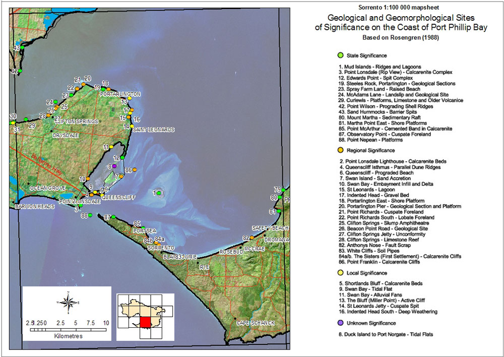
Sites of Geological and Geomorphological Significance - Sorrento 1 Mud Island Ridges and Lagoons 3 Point Lonsdale (Rip View) - Calcarenite Complex 12 Edwards Point - Spit Complex 19 Steeles Rock, Portarlington - Geological Section 23 Spray Farm Land - Raised Beach 24 McAdams Lane - Landslip and Geological Site 29 Curlewis - Platforms, Limestone and Older Volcanics 42 Point Wilson - Prograding Shell Ridges 43 Sand Hummocks - Barrier Spits 80 Mount Martha - Sedimentary Raft 81 Martha Point East - Shore Platforms 85 Point McArthur - Cemented Band in Calcarenite 87 Observatory Point - Cuspate Foreland 88 Point Nepean - Platforms 2 Point Lonsdale Lighthouse - Calcarenite Beds 4 Queenscliffe Isthmus - Parallel Dune Ridges 6 Queenscliff - Prograded Beach 7 Swan Island - Sand Accretion 10 Swan Bay - Embayment Infills and Delta 15 St Leonards - Lagoon 17 Indented Head - Gravel Bed 20 Portarlington Pier - Geological Section and Platform 21 Point Richards - Cuspate Foreland 22 Point Richards South - Lobate Foreland 25 Clifton Springs - Slump Amphitheatre 26 Beacon Point Road - Geological Site 27 Clifton Spring Jetty - Unconformity 28 Clifton Springs - Limestone Reef 82 Anthonys Nose - Fault Scarp 83 White Cliffs - Soil Pipes 84 The Sisters (First Settlement) - Calcarenite Cliffs 86 Point Franklin - Calcarenite Cliffs 5 Shortland Bluffs - Calcarenite Beds 9 Swan Bay - Tidal Flat 11 Swan Bay - Alluvial Fans 13 The Bluff (Miller Point) - Active Cliff 14 St Leonards Jetty - Cuspate Spit 16 Indented Head South - Deep Weathering 8 Duck Island to Port Norgate - Tidal Flats

Sites of Geological and Geomorphological Significance - Sorrento
State Significance20 Portarlington Pier - Geological section and platform
1 Mud Islands - Ridges and Lagoons21 Point Richards - Cuspate foreland
3 Point Lonsdale (Rip View) - Calcarenite complex22 Point Richards South - Lobate foreland
12 Edwards Point - Spit complex25 Clifton Springs - Slump amphitheatre
19 Steels Rock, Portarlington - Geological significance26 Beacon Point Road - Geological site
23 Spray farm land - Raised beach27 Clifton Springs jetty - Unconformity
24 McAdams Lane - Landslip and geological site28 Clifton Springs - Limestone reef
29 Curlewis - Platforms, limestone and older volcanics82 Anthony's Nose - Fault scarp
42 Point Wilson - Prograding shell ridges83 White Cliffs - Soil pipes
43 Sand Hummocks - Barrier spits84a/b The Sisters (First Settlement) - Clacarenite cliffs
80 Mount Martha - Sedimentary raft86 Point Franklin - Calcarenite cliffs
81 Martha Point east - Shore platforms
85 Point McArthur - Cemented band in CalcareniteLocal Significance
87 Observatory Point - Cuspate foreland5 Shorelands Bluff - Calcarenite beds
88 Point Nepean - Platforms9 Swan Bay - Tidal flat
11 Swan Bay - Alluvial fans
Regional Significance13 The Bluff (Miller Point) - Active cliff
2 Point Londsale Lighthouse - Calcaenite beds14 St Leonards jett - Cuspate spit
4 Queenscliff Isthmus - Parallel dune ridges16 Indented Head South - Deep Weathering
6 Queenscliff - Prograded beach
7 Swan Island - Sand accretionUnknown Significance
10 Swan Bay - Embayment infill and delta8 Duck Island to Port Norgate - Tidal flats
15 St Leonards - Lagoon
17 Indented Head - Gravel bed
18 Portarlington East - Shore platform
Page top