
25 Clifton Springs - Slump Amphitheatre
|
This information has been developed from one or more of these publications:
|
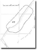
| Location | 878758 to 876756. The site begins at a long, deep gully 500 m north of the car park at the end of Beacon Point Road, and extends for 400 m north of the gully. | 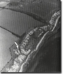 Site 25, Clifton Springs slump amphitheatre |
Access | Beacon Point Road. | |
Ownership/Managing Authority | Crown land (Port of Geelong Authority) below high water mark; private land above high water mark. | |
Site Description | The site encloses a long, bowl-shaped landslip with a high, gullied headwall scarp of grey silty clays and fine sands. The complex is a major slump amphitheatre that has undergone more coastal recession than that to the north of McAdams lane, and as a consequence, the coastal outcrops are less well exposed. At the northeastern end there is a deep, active, branching erosion gully that is cutting back into the plateau behind the scarp. The shore platform at the western end of the site is a fault-bounded outcrop of a limestone member (Curlewis Limestone) of the Fyansford Formation. | |
Significance | Regional. The site is a clear example of a major backward rotational coastal landslip. The back tilting is less pronounced than at Site 21 and the outer (seaward) cliff is lower. It therefore has interest for field mapping and comparison on the forms and processes at the two sites. It also illustrates a process of cliff formation that is indirectly related to marine processes. The northern gully is the largest active gully on the Bellarine Peninsula and has only been recently generated or re-activated. | |
Management Considerations | Class 2. The site would be best left intact as a working model of post-landslip landform development. This activity poses no threat to existing structures although the headwall of the largest active gully could be treated to reduce the loss of the adjacent property. The site is probably geotechnically unsuitable for building development because of the landslip history and the erosional activity of the cliffs. | |
References | Ladd, P.G. (1971) | |
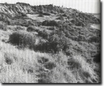 Site 25, Low seaward slope of slump amphitheatre north of Clifton Springs | 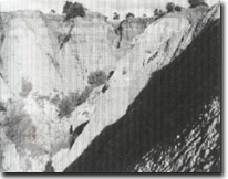 Site 25, Gully in headwall scarp of slump amphitheatre north of Clifton Springs |

© State of Victoria (Agriculture Victoria) 1996 - 2025.

This work, Victorian Resources Online, is licensed under a Creative Commons Attribution 4.0 licence. You are free to re-use the work under that licence, on the condition that you credit the State of Victoria (Agriculture Victoria) as author, indicate if changes were made and comply with the other licence terms.
The licence does not apply to ‘branding’ or some ‘images or photographs’ that may be owned by third parties. We ask you to seek prior approval to use images using the VRO feedback form. Access to higher quality images can also be provided on request.
This page was last updated on 23/11/2018.