
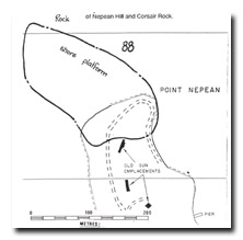
88 Point Nepean - Platforms
|
This information has been developed from one or more of these publications:
|
| Location | 932578. Western end of Point Nepean, including shore platforms extending to the rock stack with the beacon. | |
| Access | Nepean Highway. | |
| Ownership/Managing Authority | Crown Land, Department of Conservation, Forests and Lands. | |
Site Description | The site encloses the tapering western edge of the Nepean Peninsula, and includes the rock stack (Beacon Rock) (isolated at high tide) and shore platforms that lie west of Nepean Hill. The geology of the area is dune calcarenite, and the cliffs, rock stacks and shore platforms display and array of limestone weathering features including pinnacles, solution pits and notches and there is a wave ramp and visor around the base of the stack. The site is of particular interest for the continuity of the shore platform which extends from the Port Phillip Bay coast to the Bass Strait coast between the base of Nepean Hill and Corsair Rock. | |
Significance | State. The site includes one of the geological landmarks of the Victoria coast i.e. the narrow entrance to Port Phillip Bay and illustrates the truncation of the Nepean Bay Bar. Many of the geomorphological features of Port Phillip Bay are related tot he nature of this constricted entrance, such as the Port Phillip Sands, Mud Islands, Point Lonsdale and Observatory Point. The site shows the structure of the dune rock of the Nepean Peninsula, illustrates the processes that have shaped and modified the bar and the entrance to Port Phillip Bay and provides an unusual example of a shore platform developing in contrasting wave environments. A permanent sea level monitoring transect could be established across the platform between Bass Strait and Port Phillip Bay. | |
Management Considerations | Class 2. Detailed evaluation of the effectiveness of further artificial structures should be carried out before extending these structures towards or around Beacon Rock. | |
References | Keble, R.A. (1946; 1950) | |
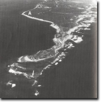 Site 88, Point Nepean, the south western end of the Nepean Peninsula marking the eastern side of the entrance to Port Phillip Bay. A broad shore platform extends between Bass Strait and Port Phillip Bay between Point Nepean and the rock stack (arrow). Observatory Point (A) is in Port Phillip Bay, while to the right of the photograph is the high energy, indented, Bass Strait coast. Note the contrasting wave conditions (as indicated by the surf zone) in Bass Strait compared with Port Phillip Bay |

© State of Victoria (Agriculture Victoria) 1996 - 2025.

This work, Victorian Resources Online, is licensed under a Creative Commons Attribution 4.0 licence. You are free to re-use the work under that licence, on the condition that you credit the State of Victoria (Agriculture Victoria) as author, indicate if changes were made and comply with the other licence terms.
The licence does not apply to ‘branding’ or some ‘images or photographs’ that may be owned by third parties. We ask you to seek prior approval to use images using the VRO feedback form. Access to higher quality images can also be provided on request.
This page was last updated on 23/11/2018.