
86 Point Franklin - Calcarenite Cliffs
|
This information has been developed from one or more of these publications:
|
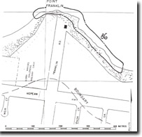
| Location | 005653. Headland 500 m east of Portsea Pier. The most significant features lie on the eastern and western sides of the point. | 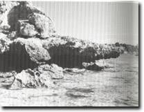 Site 86, Notch and visor west of Point Franklin |
| Access | Franklin Road. There are steps to the east of Point Franklin and a footpath to the western side. It is difficult to traverse the base of the point except at very low tides. | |
| Ownership/Managing Authority | Crown land, Portsea Foreshore Committee of Management | |
Site Description | The site is an irregular cliff of calcarenite displaying cross bedding, palaeosols and weathering features. There is a weakly developed and fragmentary shore platform. Two features of special interest occur – on the western edge is an overhanging ledge that has the form of an exaggerated notch and visor, and 100 m east of the steps on the eastern side is a cave eroded along the inclined bedding places of the calcarenite. | |
Significance | Regional. While these features are common on the calcarenite of the ocean coast of the Nepean Peninsula, they are unusual in Port Phillip Bay. The overhanging ledge is a particularly well developed example of this erosional development of calcarenite, and is uncommon in other rocks. | |
Management Considerations | Class 1. The features should be left in present condition and not be modified or protected by dumped boulders or sea walls. Any cliff-top construction or stabilisation should be designed so as not to cause damage to the two features described. | |
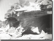 Site 86, Cave eroded along inclined bedding plains, Point Franklin |

© State of Victoria (Agriculture Victoria) 1996 - .

This work, Victorian Resources Online, is licensed under a Creative Commons Attribution 4.0 licence. You are free to re-use the work under that licence, on the condition that you credit the State of Victoria (Agriculture Victoria) as author, indicate if changes were made and comply with the other licence terms.
The licence does not apply to ‘branding’ or some ‘images or photographs’ that may be owned by third parties. We ask you to seek prior approval to use images using the VRO feedback form. Access to higher quality images can also be provided on request.
This page was last updated on .