
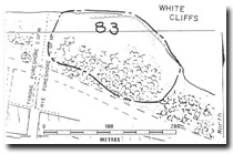
83 White Cliffs - Soil Pipes
|
This information has been developed from one or more of these publications:
|
| Location | 087510. Cliffed headland 1 km west of the Rye Jetty. | |
Access | Nepean Highway. Parking area opposite White Cliffs Road. | |
Ownership/Managing Authority | Crown land, Shire of Flinders. | |
Site Description | These are high calcarenite cliffs at the end of a ridge of dune calcarenite, and were at one time probably a cliff stack isolated from the main body of calcarenite of the Nepean Peninsula. They show cavernous weathering and deflation hollows in the upper layers, and there are some striking exposures of red-brown soil pipes filling solution cavities in the upper calcrete bed. This bed is bleached, hard calcarenite and lies between beds of different texture and colour. | |
Significance | Regional. This is the best display of soil pipes and complex calcrete development on the Port Phillip Bay coast of the Nepean Peninsula. The outcrop is the most northerly coastal exposure of calcrete in the Bay and marks the geological beginning of the Nepean Peninsula, which is composed almost entirely of this dune rock. | |
| Management Considerations | Class 2. The site is an important and accessible teaching site to show weathering modification of the calcarenite beds. The upper horizons should not be covered or reclaimed but left as geological exposures. | |

© State of Victoria (Agriculture Victoria) 1996 - .

This work, Victorian Resources Online, is licensed under a Creative Commons Attribution 4.0 licence. You are free to re-use the work under that licence, on the condition that you credit the State of Victoria (Agriculture Victoria) as author, indicate if changes were made and comply with the other licence terms.
The licence does not apply to ‘branding’ or some ‘images or photographs’ that may be owned by third parties. We ask you to seek prior approval to use images using the VRO feedback form. Access to higher quality images can also be provided on request.
This page was last updated on .