
42 Point Wilson - Prograding Shell Ridges
|
This information has been developed from one or more of these publications:
|
| Location | 816816. Coastal ridges adjacent to the Point Wilson jetty. | 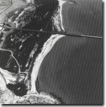 Site 42, Shelly ridges and saltmarsh, Point Wilson |
Access | Point Wilson Road. (Restricted to public access). | |
Ownership/Managing Authority | Commonwealth land (Department of Transport). | |
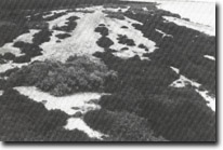
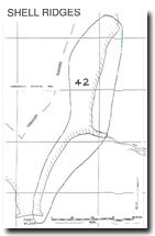
Site Description | Adjacent to the Point Wilson jetty is an extensive belt of low, sparsely vegetated shelly ridges lying parallel to the coast and backed by a broad salt marsh. The salt marsh is a dense shrubland of Sclerostegia arbuscula (Shrubby Glasswort) around pools and open saline pans. The marsh also has a ridged shelly substrate although this is masked by the vegetation cover. North of the jetty, the frontal shell ridge zone is 60 m to 70 m wide, the ridges averaging 1 m in height with flattened crests spaced 8 m to 10 m apart. There is an irregular distribution of Sclerostegia arbuscula, Atriplex australasia (Grey Saltbush) and Sueda australis (Austral Seablite). 500 m north of the jetty is a broad, unvegetated cuspate zone coinciding with a slight change in coastal orientation. South of the jetty, the ridge zone narrows and there is a complex pattern of ridge convergence, indicating cut and fill episodes. | |
The ridges consist largely of bivalves, occurring as single and paired valves, large broken fragments and in finely comminuted form. The outermost ridge includes a distinctive band of small, unbroken gastropods. Although the growth of the outer ridges has been influenced by the emplacement of the rock embankment leading to the jetty, much of the ridge growth predates this structure. | ||
The ridges have advanced in front of a low basalt bluff and have covered a basalt platform which may be seen at Point Wilson south of the jetty. | ||
Significance | State. The ridges are an outstanding example of a shell-dominated coastal compartment and a rare example of actively prograding coastal ridges. The contrast in form and vegetation cover between the inner and outer ridges is of particular significance. The site has not been the subject of detailed geomorphological study and could form the basis of a major research project. | |
Management Considerations | Class 1. Vegetation clearing and topographic changes due to building, excavation, extension of harbour facilities or emplacement of other structures would seriously degrade the site. If coastal facilities had to be extended, it would be preferable to locate these to the south of the jetty or west of Point Wilson. The ridges north of the jetty are the least disturbed, and preference should be given to retaining these in an unmodified form. | |
 Site 42, Shelly beach ridges, Point Wilson |

© State of Victoria (Agriculture Victoria) 1996 - .

This work, Victorian Resources Online, is licensed under a Creative Commons Attribution 4.0 licence. You are free to re-use the work under that licence, on the condition that you credit the State of Victoria (Agriculture Victoria) as author, indicate if changes were made and comply with the other licence terms.
The licence does not apply to ‘branding’ or some ‘images or photographs’ that may be owned by third parties. We ask you to seek prior approval to use images using the VRO feedback form. Access to higher quality images can also be provided on request.
This page was last updated on .