
15 St Leonards - Lagoon
|
This information has been developed from one or more of these publications:
|
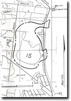
| Location | 005740. 2 km north of St Leonards Jetty. | 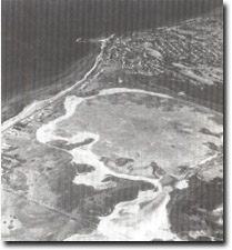 Site 15, Salt lagoon, St Leonards |
Access | The Esplanade, Ibbotson St, and Dossetor Road, St Leonards. | |
Ownership/Managing Authority | Private and Crown land: Department of Conservation, Forests and Lands (Wildlife Research). | |
Site Description | The site is a large, often dry, coastal lagoon with a clay/salt floor. There is a main southern basin connected by a narrow channel to a smaller northern extension. To the west and south there is a well-defined, generally continuous bluff that appears to mark the shoreline of a former marine embayment. Relict beaches, spits and islands occur in both basins. There is no obvious former tideway to connect the lagoon to Port Phillip Bay, but there are two sites where such a connection seems likely. One is at the southeastern edge of the lagoon where there is a low sandy ridge only 40 m wide separating the lagoon from the bay, and the other is a marshy area north of Dossetor Road. | |
Significance | Regional. The site is the only such feature on the coast of Port Phillip Bay to retain many recognizable elements of a former marine embayment now isolated by coastal deposition. The extent and age of marine influence on the site is unknown, and there is no information about its geomorphological evolution. It is an important site in determining the history of sedimentation on the southeastern coast of Port Phillip Bay and comprises a suitable research site. | |
Management Considerations | Class 2. Minimal physical interference to the shoreline features is required to retain the significance of the site. Residential sub-division of lowland areas adjacent to the lagoon should be restricted, especially around the two probable former tidal entrances. Building of causeways and landfill reclamation of the edges would substantially degrade the site. | |
Site 15, Salt lagoon, St Leonards

© State of Victoria (Agriculture Victoria) 1996 - .

This work, Victorian Resources Online, is licensed under a Creative Commons Attribution 4.0 licence. You are free to re-use the work under that licence, on the condition that you credit the State of Victoria (Agriculture Victoria) as author, indicate if changes were made and comply with the other licence terms.
The licence does not apply to ‘branding’ or some ‘images or photographs’ that may be owned by third parties. We ask you to seek prior approval to use images using the VRO feedback form. Access to higher quality images can also be provided on request.
This page was last updated on .