
43 Sand Hummocks - Barrier Spits
|
This information has been developed from one or more of these publications:
|
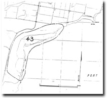
| Location | 820855. Embayment, barrier spits and associated wetland 4 km north of Point Wilson. | 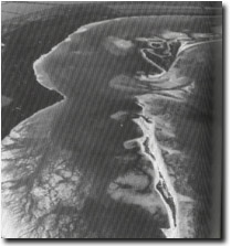 Site 43, Northern spit and barrier system, Sand Hummocks |
Access | Twenty Nine Mile Road. | |
Ownership/Managing Authority | Crown land (Wildlife Reserve, Port of Geelong Authority, Department of Conservation, Forests and Lands, MMBW, Geelong Regional Commission), and some private land. | |
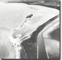
Site Description | The Sand Hummocks is a shallow, largely infilled tidal embayment and lagoon formed by the sea flooding a gently sloping depression on the surface of the Werribee Plains. The lagoon is partly enclosed by narrow barrier spits that are surmounted by beach ridges an crossed by tidal entrances of variable position and size. The inner margin of the site is defined by a low bluff that extends up to 1 km inland from high water mark of the lagoon shore. The bluff is an abandoned shoreline cut at the maximum stage of the Holocene marine transgression before the filling of the embayment by sediments and salt marsh. In places the bluff is marked by an abrupt interface 30 to 40 cm high separating the embayment from the basalt plains, but elsewhere it is degraded to a sloping surface that merges with the marsh terrain. In front of the bluff, is a complex zoned salt marsh developed on the sand, mud and shells of the embayment infill. The marsh includes unvegetated saline and clay pans, open shrubland of Halosarcia halecnemoides, herbfields of Sarcocornia quinqueflora and Frankenia pauciflora, sedgelands of Ghania filum and closed shrubland of Sclerostegia arbuscula. The salt marsh is dissected by a well developed network of tidal drainage channels, some of which terminate in salt pans at the rear of the marsh. | |
Sandy ridge enclosed in the marsh are relict spits or cheniers emplaced by wave action before the salt marsh reached its present extent. | ||
The shallow tidal lagoon at the Sand Hummocks lies behind elongate barrier spits that parallel the trend of the coastline and extend 300 to 500 m offshore. The spits are built of sand, shells and basalt pebbles, are of variable width and surmounted by vegetated beach ridges to 1.5 m high. There are three main spits, with several tidal crossings and a number of low washover sectors. Flood tide deltas and distributary channels extend from these points into the lagoon. The southern spit appears to be shrinking and the breach between this and the central spit, (initiated by storm overwash in 1978), is becoming wider. The spit systems are dynamic and highly mobile features. | ||
Significance | State. The lagoon and barrier spits have no counterpart in Port Phillip Bay and are unusual features in the context of the Victorian coast. The scale of barrier development may be compared to that of the sand islands at Corner Inlet. It is an outstanding example of a tidal lagoon system not modified by land drainage but dominated by storm wave and tidal processes. The system constitutes a very significant site for the study of tidal and wave action in the formation and migration of barrier systems, and for sedimentation rates and processes in shallow lagoons. The marine and onshore components of the site include many features such as relict erosional and depositional landforms, sandy, muddy and biogenic sediments, and vegetation sequences, that are relevant for the study of Holocene and contemporary sea levels in Port Phillip Bay. | |
Management Considerations | Class 1. Although peripheral parts of the site have been modified by activities related to the MMBW farm, this is still a substantially intact natural system. No further drainage, reclamation, roadworks, buildings, alteration of tidal flow, coastal engineering, harbour, or extractive industries should be permitted on the site area. Land drainage should not be channelled into or through the salt marsh area or the lagoon. The area would be well suited to management as a wildlife refuge to allow geomorphological processes to operate without modification. | |
References | Bowler, J.M. (1966) Jurkowski, I. (1980) | |
 Site 43, Northern spit and barrier system, Sand Hummocks |

© State of Victoria (Agriculture Victoria) 1996 - .

This work, Victorian Resources Online, is licensed under a Creative Commons Attribution 4.0 licence. You are free to re-use the work under that licence, on the condition that you credit the State of Victoria (Agriculture Victoria) as author, indicate if changes were made and comply with the other licence terms.
The licence does not apply to ‘branding’ or some ‘images or photographs’ that may be owned by third parties. We ask you to seek prior approval to use images using the VRO feedback form. Access to higher quality images can also be provided on request.
This page was last updated on .