
3 Point Lonsdale (Rip View) - Calcarenite Complex
|
This information has been developed from one or more of these publications:
|
| Location | 914593 to 913596. Point Lonsdale Cliffs beginning at walkway below RIP View Lookout and extending north towards Kirk Road. | 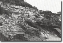 Site 3, Truncated dune bedding at base of Rip View carpark walkway. |
| Access | RIP View Lookout carpark and walkways off Point Lonsdale Road. | |
| Ownership/Managing Authority | Crown Land (Borough of Queenscliff, Department of Conservation Forests and Lands, and Port of Melbourne Authority). | |
Site Description | Cliffs developed in the complex calcarenite beds extend from the base of RIP View Lookout north around the headland towards Point Lonsdale township. The cliffs have excellent sections of dune limestone and show a variety of bedding structures, joints and episodes of weathering and soil development. At the base of the walkway from RIP View Point is a very clear example of truncated bedding at the top of a fossil dune sequence. In the north of the site where cliffs are up to 15 m high, the upper several metres of calcarenite is deeply weathered and the kunkar horizon is a complex of platey calcrete, infilled soil pipe and tubes, cemented brecciated blocks and fine, white, leached sand. The uppermost horizon has a dark brown terra rossa soil, overlain by dark sand with a substantial shell midden buried by brown sand and soil. | |
Significance | State. The cliffs are one of the most safely accessible and complex examples in Victoria of the Pleistocene calcareous dune sequences that are well-developed on much of the southern and western sectors of the Victorian coast. There are excellent examples of Aeolian bedding, truncation of sequences, variation in grain size, degree of lithification and development of weathering horizons. Although there are similar sites on the Bass Strait coast of the Nepean Peninsula, these are exposed localities and the sites are disturbed by blowing sand and erosion in a more vigorous wind and wave regime of the ocean coast. The thick kunkar upper horizon an the kitchen midden that overlies it are of particular importance in the significance of evaluation. | |
Management Considerations | Class 2. The site should be kept clear of derelict barriers, rubbish and fallen trees and shrubs. There should be no artificial stabilization of cliff slopes, planting of vegetation or construction of protective barriers of vegetation or construction of protective barriers or walkways that would interfere with the exposure - particularly the upper sections. The site requires a design study to determine the most appropriate means of access and traverse of the cliff base, face and top, that would allow adequate study of the geological features. | |
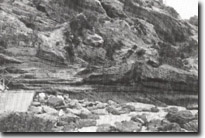 Site 3, Thick kunkar and calcrete developed on dune calcarenite RIP View. | 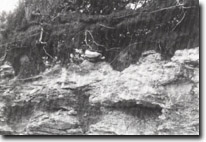 Site 3, Calcrete and shell midden, Rip View. | 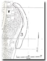 Site 3, RIP View, Point Lonsdale |

© State of Victoria (Agriculture Victoria) 1996 - 2025.

This work, Victorian Resources Online, is licensed under a Creative Commons Attribution 4.0 licence. You are free to re-use the work under that licence, on the condition that you credit the State of Victoria (Agriculture Victoria) as author, indicate if changes were made and comply with the other licence terms.
The licence does not apply to ‘branding’ or some ‘images or photographs’ that may be owned by third parties. We ask you to seek prior approval to use images using the VRO feedback form. Access to higher quality images can also be provided on request.
This page was last updated on 23/11/2018.