
2 Point Lonsdale Lighthouse - Calcarenite Beds
|
This information has been developed from one or more of these publications:
|
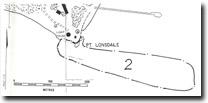
| Location | 912599. Point Lonsdale. Cliffs and shore platforms immediately south of the Point Lonsdale Lighthouse, including Buckleys Cave. | 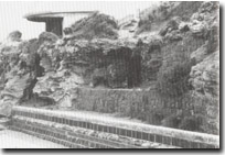 Site 2, Calcarenite and calcrete at Buckleys Cave, Point Lonsdale |
| Access | Point Lonsdale Road and walking track inside the Lighthouse Reserve. | |
| Ownership/Managing Authority | Crown Land (Borough of Queenscliff and Department of Conservation, Forests and Lands) and Commonwealth Land (Department of Transport). | |
| Site Description | The cliffs and shore platforms are in Pleistocene dune limestone (calcarenite) with unconsolidated sands at the cliff top. There are numerous beds with the variable dip characteristic of the calcarenite formations well exposed both in the cliffs, the platform and in small cliff stacks in front of the lighthouse. The upper section of the cliffs shows an irregular kunkar or travertine layer up to 1 m thick developed in the dune limestone. Buckleys Cave (probably a composite solutional and collapse feature which has been partly excavated by wind and storm wave action) has a sandy floor about 2 m above high water mark. The narrow entrance (closed by a locked steel grille), opens to a chamber approximately 4 m wide, 15 m long and 3 m high. The cave is defended by two masonry and cement walls which accentuate the infilling of the sandy floor and make it difficult to evaluate the role of marine processes in cave formation. | |
The shore platform extends approximately 200 m eastward of the lighthouse cliffs forming an intertidal peninsula into Port Phillip Bay. Extending beyond the exposed platform towards the entrance to Port Phillip Bay, are reefs and intertidal islands which are remnants of the earlier stages of platform and cliff development here. The seaward part of the platform has very little slope and is studded with shallow abrasion and solution potholes. At the cliff base, the platform is an abrasion ramp up to 10 m wide sloping at 5o to 8o but interrupted by the variable dip of the limestone beds. The ramp is crossed by several shallow sinuous channels. | ||
Significance | Regional. The site is a clear and easily accessible example of calcarenite cliffs and shore platform features including bedding, weathering, cave and hollow development and platform evolution. Plan and section views of the calcarenite beds may be observed at low tide with less hazard than is the case on the higher energy limestone coasts in Victoria. The intertidal peninsula is important to illustrate the geological relationship of Point Lonsdale with Point Nepean (the former Nepean bar) and to demonstrate the retreat and widening of the Port Phillip Bay entrance by recession of the calcarenite cliffs. The site was the subject of one of the earliest scientific papers detailing forms and processes of calcarenite shore platform development (Jutson, 1948) and allows comparison of his illustrations and description with the current form of the platform, cliffs and stacks. | |
Management Considerations | Class 2. The aim is to prevent introduced coastal defence materials (rocks, masonry, cement) from becoming mobilized and washed onto the ramp or platform. No loose boulder walls should be erected and the existing cemented structures be extended on or across the platform or permitted to obscure the upper calcarenite cliff sections showing the kunkar beds. The barrier across the entrance to Buckleys Cave should be removed. | |
References | Jutson, J.T. (1948) | |
Site 2, Point Lonsdale

© State of Victoria (Agriculture Victoria) 1996 - 2025.

This work, Victorian Resources Online, is licensed under a Creative Commons Attribution 4.0 licence. You are free to re-use the work under that licence, on the condition that you credit the State of Victoria (Agriculture Victoria) as author, indicate if changes were made and comply with the other licence terms.
The licence does not apply to ‘branding’ or some ‘images or photographs’ that may be owned by third parties. We ask you to seek prior approval to use images using the VRO feedback form. Access to higher quality images can also be provided on request.
This page was last updated on 23/11/2018.