
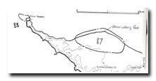
87 Observatory Point - Cuspate Foreland
|
This information has been developed from one or more of these publications:
|
| Location | 970575. 3 km west of Portsea. | 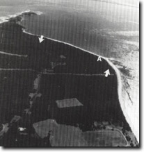 Site 87, Observatory Point (A), viewed eastward toward Point Nepean and The Rip. The zone of accretionary ridges is shown by the arrows |
| Access | Nepean Highway. | |
| Ownership/Managing Authority | Crown land (Commonwealth Department of Defence, Department of Conservation, Forests and Lands). | |
Site Description | Observatory Point is the outer edge of a broad rounded foreland built of a succession of parallel sandy ridges. A long history of progradation is evident at the site with the foreland having been built forward several hundred metres in front of a former low cliffed shoreline cut into the Pleistocene dune calcarenite. On the western side of the point, these ridges are undergoing minor erosion but new, low ridges are being built on the eastern side. | |
Significance | State. The site is one of very few localities on the coast of Port Phillip Bay to show sustained sandy accretion. It contains the least disturbed sequence of sandy ridges and associated vegetation in the bay and comprises one of the best such localities on the coast of Victoria. It is an important site to determine sand budgets and former depositional sequences as well as providing opportunity to monitor morphological and vegetative development of sand ridges. Observatory Point is the eastern Port Phillip Bay equivalent of Swan Island, and indicates the sedimentation regime related to the tidal and wave movement of sand through Port Phillip Heads. | |
Management Considerations | Class 1. Minimal disturbance of the site is recommended, including the maintenance of the vegetation of the developing ridges. Visitor facilities and car access should be restricted to the far western edge of the site. | |
References | Bird, E.C.F. (1980) | |
Site 87, Accretionary ridges on the eastern side of Observatory Point |

© State of Victoria (Agriculture Victoria) 1996 - .

This work, Victorian Resources Online, is licensed under a Creative Commons Attribution 4.0 licence. You are free to re-use the work under that licence, on the condition that you credit the State of Victoria (Agriculture Victoria) as author, indicate if changes were made and comply with the other licence terms.
The licence does not apply to ‘branding’ or some ‘images or photographs’ that may be owned by third parties. We ask you to seek prior approval to use images using the VRO feedback form. Access to higher quality images can also be provided on request.
This page was last updated on .