
6 Queenscliff - Prograded Beach
|
This information has been developed from one or more of these publications:
|
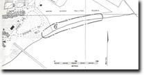
| Location | 958619. Beach and foredune area north of the Boat Pier, Queenscliff. | 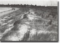 Site 6, Prograding beach with sand terrace, Queenscliff |
Access | Symonds Street or Larkin Parade, Queenscliff. | |
Ownership/Managing Authority | Crown land. Borough of Queenscliff. | |
Site Description | North of the Black Lighthouse Queenscliff, the coastal bluff is fronted by a wide sandy terrace, built by sand entering Port Phillip Bay borne by wave and tidal current, and lodging on the northwestern side of the entrance. Since the construction of the sheet piling training wall to protect the entrance to Queenscliff harbour in 1956, the terrace has undergone rapid progradation and the shoreline south of the breakwater is about 250 m seaward of the 1949 position. The recent progradation is a result of the breakwater interrupting the northward drift of sand towards Swan Island. North of the Boat Pier, the terrace has a well defined foredune with a cliffed seaward margin indicating episodes of ‘cut’ or erosion. An incipient foredune is building in front of this and becoming colonised by Cakile and Spinifex. | |
Significance | Regional. The site is important to demonstrate that sand moves into Port Phillip Bay and accumulates on the western side of the entrance. It is an onshore example of the process by which Swan Island, the Port Phillip Sands tidal delta and Mud Islands has developed. It also illustrates that rapid accretion can occur when artificial structures interrupt a substantial coastal sand movement. It is one f the few sites in the Bay where rapid sand accretion has occurred in recent decades and where the morphology of developing sandy forelands and foredunes can be studied. | |
Management Considerations | Class 2. The site should be maintained as a working model of foredune and sand beach development. Development on, or reclamation of the backshore and dune areas, should not proceed beyond the present limit, allowing a sufficient buffer zone to take account of future episodes of erosion. | |
References | Riedel, H.P. & Fidge, B.L. (1977) | |
 Site 6, Queenscliff, prograded beach | 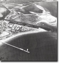 Site 6, Prograded beach sector at Queenscliff |

© State of Victoria (Agriculture Victoria) 1996 - .

This work, Victorian Resources Online, is licensed under a Creative Commons Attribution 4.0 licence. You are free to re-use the work under that licence, on the condition that you credit the State of Victoria (Agriculture Victoria) as author, indicate if changes were made and comply with the other licence terms.
The licence does not apply to ‘branding’ or some ‘images or photographs’ that may be owned by third parties. We ask you to seek prior approval to use images using the VRO feedback form. Access to higher quality images can also be provided on request.
This page was last updated on .